

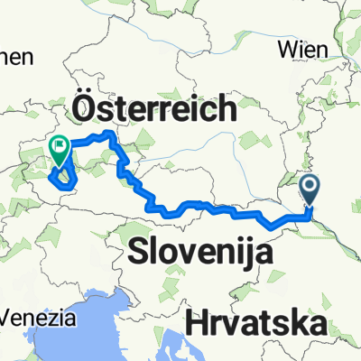
Szlovénia _ Horvátország %17 km 6100 szint
A cycling route starting in Lenti, Zala County, Hungary.
Overview
About this route
Szlovénia _ Horvátország
- -:--
- Duration
- 454.2 km
- Distance
- 2,659 m
- Ascent
- 2,786 m
- Descent
- ---
- Avg. speed
- ---
- Max. altitude

Route quality
Waytypes & surfaces along the route
Waytypes
Road
81.8 km
(18 %)
Quiet road
63.6 km
(14 %)
Surfaces
Paved
290.7 km
(64 %)
Unpaved
22.7 km
(5 %)
Asphalt
286.1 km
(63 %)
Gravel
18.2 km
(4 %)
Continue with Bikemap
Use, edit, or download this cycling route
You would like to ride Szlovénia _ Horvátország %17 km 6100 szint or customize it for your own trip? Here is what you can do with this Bikemap route:
Free features
- Save this route as favorite or in collections
- Copy & plan your own version of this route
- Split it into stages to create a multi-day tour
- Sync your route with Garmin or Wahoo
Premium features
Free trial for 3 days, or one-time payment. More about Bikemap Premium.
- Navigate this route on iOS & Android
- Export a GPX / KML file of this route
- Create your custom printout (try it for free)
- Download this route for offline navigation
Discover more Premium features.
Get Bikemap PremiumFrom our community
Other popular routes starting in Lenti
 Otthonról haza Kerékpártúra a Veleméri templomhoz
- Distance
- 48.1 km
- Ascent
- 117 m
- Descent
- 109 m
- Location
- Lenti, Zala County, Hungary
 Kerékpárral a Kerka és a Mura mentén (Lentiből a Mura-völgyén Nagykanizsáig)
- Distance
- 76.9 km
- Ascent
- 113 m
- Descent
- 130 m
- Location
- Lenti, Zala County, Hungary
 glockner2
- Distance
- 640.6 km
- Ascent
- 6,418 m
- Descent
- 4,672 m
- Location
- Lenti, Zala County, Hungary
 031 Lendva-hegy
- Distance
- 9.2 km
- Ascent
- 211 m
- Descent
- 213 m
- Location
- Lenti, Zala County, Hungary
 Redics-Enese
- Distance
- 165.3 km
- Ascent
- 234 m
- Descent
- 289 m
- Location
- Lenti, Zala County, Hungary
 15. Pannon maraton, Lenti 120
- Distance
- 115.8 km
- Ascent
- 388 m
- Descent
- 388 m
- Location
- Lenti, Zala County, Hungary
 Átkötés Lenti és Letenye között
- Distance
- 35.6 km
- Ascent
- 130 m
- Descent
- 149 m
- Location
- Lenti, Zala County, Hungary
 Nemesnép - Őriszentpéter
- Distance
- 39.8 km
- Ascent
- 285 m
- Descent
- 217 m
- Location
- Lenti, Zala County, Hungary
Open it in the app