B2B00247 55304>55304 via Foley Blvd, 117th Av & Davenport St
A cycling route starting in Andover, Minnesota, United States.
Overview
About this route
Radisson Rd has a nice path and also a shoulder.
- -:--
- Duration
- 21.8 km
- Distance
- 17 m
- Ascent
- 12 m
- Descent
- ---
- Avg. speed
- 277 m
- Max. altitude
Route quality
Waytypes & surfaces along the route
Waytypes
Cycleway
8.7 km
(40 %)
Road
7.4 km
(34 %)
Surfaces
Paved
17.5 km
(80 %)
Asphalt
17 km
(78 %)
Concrete
0.4 km
(2 %)
Undefined
4.4 km
(20 %)
Continue with Bikemap
Use, edit, or download this cycling route
You would like to ride B2B00247 55304>55304 via Foley Blvd, 117th Av & Davenport St or customize it for your own trip? Here is what you can do with this Bikemap route:
Free features
- Save this route as favorite or in collections
- Copy & plan your own version of this route
- Sync your route with Garmin or Wahoo
Premium features
Free trial for 3 days, or one-time payment. More about Bikemap Premium.
- Navigate this route on iOS & Android
- Export a GPX / KML file of this route
- Create your custom printout (try it for free)
- Download this route for offline navigation
Discover more Premium features.
Get Bikemap PremiumFrom our community
Other popular routes starting in Andover
- Killdeer Street Northwest 13007, Minneapolis to Killdeer Street Northwest 13007, Minneapolis
- Distance
- 61.9 km
- Ascent
- 82 m
- Descent
- 82 m
- Location
- Andover, Minnesota, United States
- trip through park
- Distance
- 12.8 km
- Ascent
- 28 m
- Descent
- 30 m
- Location
- Andover, Minnesota, United States
- 14558 Crane St NW, Andover to 10360 W River Rd, Brooklyn Park
- Distance
- 16.8 km
- Ascent
- 44 m
- Descent
- 61 m
- Location
- Andover, Minnesota, United States
- 14558 Crane St NW, Andover to 14586 Crane St NW, Andover
- Distance
- 12.9 km
- Ascent
- 42 m
- Descent
- 39 m
- Location
- Andover, Minnesota, United States
- by the river
- Distance
- 46.3 km
- Ascent
- 157 m
- Descent
- 158 m
- Location
- Andover, Minnesota, United States
- B2B00247 55304>55304 via Foley Blvd, 117th Av & Davenport St
- Distance
- 21.8 km
- Ascent
- 17 m
- Descent
- 12 m
- Location
- Andover, Minnesota, United States
- B2B00249 55448>55112 via 117th Av, Radisson Rd (52)
- Distance
- 20.5 km
- Ascent
- 35 m
- Descent
- 25 m
- Location
- Andover, Minnesota, United States
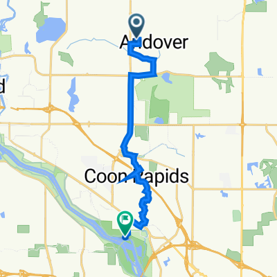
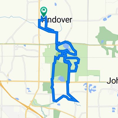
- Coon Rapids Blaine ride
- Distance
- 27.4 km
- Ascent
- 77 m
- Descent
- 79 m
- Location
- Andover, Minnesota, United States
Open it in the app