

Portes Allan Portes
A cycling route starting in La Bégude-de-Mazenc, Auvergne-Rhône-Alpes, France.
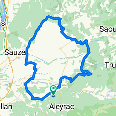
Overview
About this route
Portes Saint Gervais Puygiron Allan Portes
- -:--
- Duration
- 37.1 km
- Distance
- 248 m
- Ascent
- 285 m
- Descent
- ---
- Avg. speed
- ---
- Max. altitude

Route quality
Waytypes & surfaces along the route
Waytypes
Road
19.7 km
(53 %)
Busy road
9 km
(24 %)
Surfaces
Paved
7.7 km
(21 %)
Asphalt
7.3 km
(20 %)
Paved (undefined)
0.4 km
(1 %)
Undefined
29.3 km
(79 %)
Continue with Bikemap
Use, edit, or download this cycling route
You would like to ride Portes Allan Portes or customize it for your own trip? Here is what you can do with this Bikemap route:
Free features
- Save this route as favorite or in collections
- Copy & plan your own version of this route
- Sync your route with Garmin or Wahoo
Premium features
Free trial for 3 days, or one-time payment. More about Bikemap Premium.
- Navigate this route on iOS & Android
- Export a GPX / KML file of this route
- Create your custom printout (try it for free)
- Download this route for offline navigation
Discover more Premium features.
Get Bikemap PremiumFrom our community
Other popular routes starting in La Bégude-de-Mazenc
 Pas de Lauzun Col de la Chaudiere 1360 hm
- Distance
- 94.4 km
- Ascent
- 1,639 m
- Descent
- 1,629 m
- Location
- La Bégude-de-Mazenc, Auvergne-Rhône-Alpes, France
 Cleon Mirmande Grane Cleon 950 hm
- Distance
- 75.5 km
- Ascent
- 1,772 m
- Descent
- 1,766 m
- Location
- La Bégude-de-Mazenc, Auvergne-Rhône-Alpes, France
 Salettes wandeling
- Distance
- 3.5 km
- Ascent
- 61 m
- Descent
- 60 m
- Location
- La Bégude-de-Mazenc, Auvergne-Rhône-Alpes, France
 J5B RC2 MIPIM 2018
- Distance
- 70.7 km
- Ascent
- 387 m
- Descent
- 561 m
- Location
- La Bégude-de-Mazenc, Auvergne-Rhône-Alpes, France
 kleine Runde Le Poet
- Distance
- 87.7 km
- Ascent
- 1,160 m
- Descent
- 1,160 m
- Location
- La Bégude-de-Mazenc, Auvergne-Rhône-Alpes, France
 Portes Marsanne Roynac Portes
- Distance
- 71.5 km
- Ascent
- 804 m
- Descent
- 794 m
- Location
- La Bégude-de-Mazenc, Auvergne-Rhône-Alpes, France
 Drome provencale 1
- Distance
- 60.1 km
- Ascent
- 594 m
- Descent
- 594 m
- Location
- La Bégude-de-Mazenc, Auvergne-Rhône-Alpes, France
 Saint-Gervais-sur-Roubion - Aouste
- Distance
- 33.1 km
- Ascent
- 401 m
- Descent
- 317 m
- Location
- La Bégude-de-Mazenc, Auvergne-Rhône-Alpes, France
Open it in the app