
HighSun
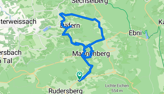
A cycling route starting in Rudersberg, Baden-Wurttemberg, Germany.
Overview
About this route
Oberndorf Däfern Fußweg nach Ebersberg Waldenweiler Mannanberg Oberndorf
- -:--
- Duration
- 20.4 km
- Distance
- 544 m
- Ascent
- 462 m
- Descent
- ---
- Avg. speed
- 527 m
- Max. altitude
Route quality
Waytypes & surfaces along the route
Waytypes
Road
10.1 km
(50 %)
Quiet road
4.4 km
(22 %)
Surfaces
Paved
16.8 km
(82 %)
Unpaved
0.1 km
(<1 %)
Asphalt
16.7 km
(82 %)
Paved (undefined)
0.1 km
(<1 %)
Continue with Bikemap
Use, edit, or download this cycling route
You would like to ride HighSun or customize it for your own trip? Here is what you can do with this Bikemap route:
Free features
- Save this route as favorite or in collections
- Copy & plan your own version of this route
- Sync your route with Garmin or Wahoo
Premium features
Free trial for 3 days, or one-time payment. More about Bikemap Premium.
- Navigate this route on iOS & Android
- Export a GPX / KML file of this route
- Create your custom printout (try it for free)
- Download this route for offline navigation
Discover more Premium features.
Get Bikemap PremiumFrom our community
Other popular routes starting in Rudersberg
 HighSun
- Distance
- 20.4 km
- Ascent
- 544 m
- Descent
- 462 m
- Location
- Rudersberg, Baden-Wurttemberg, Germany
 Lutzenberg Ebnisee Edelmannshof Klaffenbach
- Distance
- 29.9 km
- Ascent
- 464 m
- Descent
- 605 m
- Location
- Rudersberg, Baden-Wurttemberg, Germany
 Berglen-Zuffenhausen (Arbeitsweg)
- Distance
- 34.3 km
- Ascent
- 283 m
- Descent
- 282 m
- Location
- Rudersberg, Baden-Wurttemberg, Germany
 3/4 Stunde
- Distance
- 12.5 km
- Ascent
- 265 m
- Descent
- 266 m
- Location
- Rudersberg, Baden-Wurttemberg, Germany
 Wieslauftal - Ebnisee - Kesselgrotte - Waldenstein
- Distance
- 27.2 km
- Ascent
- 405 m
- Descent
- 405 m
- Location
- Rudersberg, Baden-Wurttemberg, Germany
 Ein Stunde Bergeln
- Distance
- 27.2 km
- Ascent
- 568 m
- Descent
- 569 m
- Location
- Rudersberg, Baden-Wurttemberg, Germany
 MTB Rudersberg Welzheimer Wald
- Distance
- 64.4 km
- Ascent
- 734 m
- Descent
- 734 m
- Location
- Rudersberg, Baden-Wurttemberg, Germany
 MTB rund um Rudersberg
- Distance
- 30.3 km
- Ascent
- 589 m
- Descent
- 589 m
- Location
- Rudersberg, Baden-Wurttemberg, Germany
Open it in the app