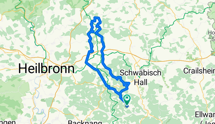
100 er Nord
A cycling route starting in Oberrot, Baden-Württemberg, Germany.
Overview
About this route
Durchs Brettachtal übers Kochertal ins Jagsttal zum Kloster Schöntal. Zurück übers Ohrntal und die Waldenburger Berge ins Rottal.
- -:--
- Duration
- 109.1 km
- Distance
- 1,358 m
- Ascent
- 1,354 m
- Descent
- ---
- Avg. speed
- 511 m
- Avg. speed
Route quality
Waytypes & surfaces along the route
Waytypes
Busy road
45.1 km
(41 %)
Road
33.1 km
(30 %)
Surfaces
Paved
95.4 km
(87 %)
Unpaved
2.2 km
(2 %)
Asphalt
89.3 km
(82 %)
Paved (undefined)
6.1 km
(6 %)
Continue with Bikemap
Use, edit, or download this cycling route
You would like to ride 100 er Nord or customize it for your own trip? Here is what you can do with this Bikemap route:
Free features
- Save this route as favorite or in collections
- Copy & plan your own version of this route
- Sync your route with Garmin or Wahoo
Premium features
Free trial for 3 days, or one-time payment. More about Bikemap Premium.
- Navigate this route on iOS & Android
- Export a GPX / KML file of this route
- Create your custom printout (try it for free)
- Download this route for offline navigation
Discover more Premium features.
Get Bikemap PremiumFrom our community
Other popular routes starting in Oberrot
- 000_35km_10-Radler_Fornsb-Kaiserb-Ebni-Rudersb-Schorndorf
- Distance
- 35 km
- Ascent
- 284 m
- Descent
- 355 m
- Location
- Oberrot, Baden-Württemberg, Germany
- Radrunde Härtsfeld - Ipf
- Distance
- 144.6 km
- Ascent
- 1,262 m
- Descent
- 1,237 m
- Location
- Oberrot, Baden-Württemberg, Germany
- RADTREFFAUSFLUG 17
- Distance
- 53.6 km
- Ascent
- 538 m
- Descent
- 520 m
- Location
- Oberrot, Baden-Württemberg, Germany
- 20160507_161646.gpx
- Distance
- 49 km
- Ascent
- 451 m
- Descent
- 450 m
- Location
- Oberrot, Baden-Württemberg, Germany
- Oberrot Oberstdorf
- Distance
- 217.5 km
- Ascent
- 954 m
- Descent
- 554 m
- Location
- Oberrot, Baden-Württemberg, Germany
- MTB SW Teil 4 Bull's River
- Distance
- 28 km
- Ascent
- 504 m
- Descent
- 503 m
- Location
- Oberrot, Baden-Württemberg, Germany
- Oberroter Wasserfälle und zurück
- Distance
- 6.8 km
- Ascent
- 226 m
- Descent
- 227 m
- Location
- Oberrot, Baden-Württemberg, Germany
- 100 er Nord
- Distance
- 109.1 km
- Ascent
- 1,358 m
- Descent
- 1,354 m
- Location
- Oberrot, Baden-Württemberg, Germany
Open it in the app