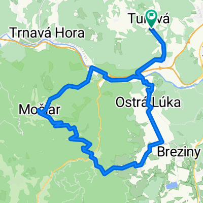
Tour the Stiavnicke jazera
A cycling route starting in Zvolen, Banská Bystrica Region, Slovakia.
Overview
About this route
Zvolen -> Ski Salamander (Dolny a Horny Hodrussky Tajch) -> Bansky Studenec (Studenecke jazero) -> Banska Stiavnica mesto -> Zvolen
- -:--
- Duration
- 92.9 km
- Distance
- 1,058 m
- Ascent
- 1,059 m
- Descent
- ---
- Avg. speed
- ---
- Max. altitude
Route quality
Waytypes & surfaces along the route
Waytypes
Track
33.3 km
(36 %)
Road
23.5 km
(25 %)
Surfaces
Paved
45.5 km
(49 %)
Unpaved
25.9 km
(28 %)
Asphalt
45.2 km
(49 %)
Ground
11.2 km
(12 %)
Continue with Bikemap
Use, edit, or download this cycling route
You would like to ride Tour the Stiavnicke jazera or customize it for your own trip? Here is what you can do with this Bikemap route:
Free features
- Save this route as favorite or in collections
- Copy & plan your own version of this route
- Split it into stages to create a multi-day tour
- Sync your route with Garmin or Wahoo
Premium features
Free trial for 3 days, or one-time payment. More about Bikemap Premium.
- Navigate this route on iOS & Android
- Export a GPX / KML file of this route
- Create your custom printout (try it for free)
- Download this route for offline navigation
Discover more Premium features.
Get Bikemap PremiumFrom our community
Other popular routes starting in Zvolen
- Malý lesný okruh
- Distance
- 31 km
- Ascent
- 724 m
- Descent
- 724 m
- Location
- Zvolen, Banská Bystrica Region, Slovakia
- SOFTIP CYKLO TOUR 2017 - Mini Geronimo
- Distance
- 7.2 km
- Ascent
- 67 m
- Descent
- 66 m
- Location
- Zvolen, Banská Bystrica Region, Slovakia
- Pred jarkami, Veľká Lúka do Pred jarkami, Veľká Lúka
- Distance
- 43.9 km
- Ascent
- 621 m
- Descent
- 600 m
- Location
- Zvolen, Banská Bystrica Region, Slovakia
- Zvolen - Sekier - Čertove Kúty - Vígľ.Huta / Kalinka
- Distance
- 18 km
- Ascent
- 538 m
- Descent
- 289 m
- Location
- Zvolen, Banská Bystrica Region, Slovakia
- SOFTIP CYKLO TOUR 2017 - Softipácka 25ka
- Distance
- 25.3 km
- Ascent
- 473 m
- Descent
- 471 m
- Location
- Zvolen, Banská Bystrica Region, Slovakia
- Naučný chodník Sliač
- Distance
- 3.9 km
- Ascent
- 98 m
- Descent
- 44 m
- Location
- Zvolen, Banská Bystrica Region, Slovakia
- Slatinské meandre
- Distance
- 27.8 km
- Ascent
- 498 m
- Descent
- 378 m
- Location
- Zvolen, Banská Bystrica Region, Slovakia
- Okolo priehrady
- Distance
- 8.2 km
- Ascent
- 176 m
- Descent
- 147 m
- Location
- Zvolen, Banská Bystrica Region, Slovakia
Open it in the app