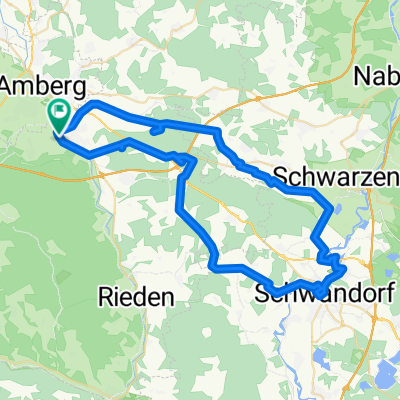
SWK - AM - Altmannshof
A cycling route starting in Kümmersbruck, Bavaria, Germany.
Overview
About this route
- -:--
- Duration
- 28.7 km
- Distance
- 226 m
- Ascent
- 223 m
- Descent
- ---
- Avg. speed
- ---
- Avg. speed
Route quality
Waytypes & surfaces along the route
Waytypes
Quiet road
9.7 km
(34 %)
Pedestrian area
6.4 km
(22 %)
Surfaces
Paved
19.5 km
(68 %)
Unpaved
2.3 km
(8 %)
Asphalt
19.3 km
(67 %)
Gravel
1.3 km
(5 %)
Continue with Bikemap
Use, edit, or download this cycling route
You would like to ride SWK - AM - Altmannshof or customize it for your own trip? Here is what you can do with this Bikemap route:
Free features
- Save this route as favorite or in collections
- Copy & plan your own version of this route
- Sync your route with Garmin or Wahoo
Premium features
Free trial for 3 days, or one-time payment. More about Bikemap Premium.
- Navigate this route on iOS & Android
- Export a GPX / KML file of this route
- Create your custom printout (try it for free)
- Download this route for offline navigation
Discover more Premium features.
Get Bikemap PremiumFrom our community
Other popular routes starting in Kümmersbruck
- längere Trainingsrunde
- Distance
- 73.8 km
- Ascent
- 784 m
- Descent
- 667 m
- Location
- Kümmersbruck, Bavaria, Germany
- Abendrunde
- Distance
- 22.9 km
- Ascent
- 228 m
- Descent
- 233 m
- Location
- Kümmersbruck, Bavaria, Germany
- Kurze Radrunde Theuern
- Distance
- 10 km
- Ascent
- 50 m
- Descent
- 51 m
- Location
- Kümmersbruck, Bavaria, Germany
- Johannisberg, Nabburg, Schwarzenfeld
- Distance
- 73.3 km
- Ascent
- 640 m
- Descent
- 640 m
- Location
- Kümmersbruck, Bavaria, Germany
- Moos - Vilshofen - Haselbach
- Distance
- 58.3 km
- Ascent
- 465 m
- Descent
- 467 m
- Location
- Kümmersbruck, Bavaria, Germany
- Vilstalalternative Theuern - Ensdorf
- Distance
- 12.8 km
- Ascent
- 217 m
- Descent
- 215 m
- Location
- Kümmersbruck, Bavaria, Germany
- Kümmersbruck_01
- Distance
- 8.4 km
- Ascent
- 71 m
- Descent
- 70 m
- Location
- Kümmersbruck, Bavaria, Germany
- Lintacher Steig, Johannisberg Marterlweg, Scharlmühle
- Distance
- 53.3 km
- Ascent
- 689 m
- Descent
- 689 m
- Location
- Kümmersbruck, Bavaria, Germany
Open it in the app