

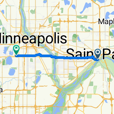
B2B00368 55102 > 55417 via Shepard Rd, Godfrey, Minnehaha, River Pkwy
A cycling route starting in Saint Paul, Minnesota, United States.
Overview
About this route
Take Kellog past 7th St, and veer right onto Eagle Pkwy.
Follow Eagle Pkwy down the hill to Shepard Rd (at the bottom of the hill).
On the river side of Shepard Rd is a bike path.
Take the Shepard Rd bike path all the way to Ford Pkwy. (Note: when you have to cross under 35E, you must follow the trail as it dips out of the way south for a little bit, but it will curve back north, don't worry!)
At Ford Pkwy, take a left and cross the bridge. When you get over the bridge, traffic is iffy for about the equivelant of 1 block. You can walk your bike on the sidewalk for this patch if you dont feel comfortable in the street.
Take a left onto 46th Ave (the first turn you can take once you're over the bridge).
Take 46th Ave down the hill to the stopsign (note: there are bumpy cobblestones for a patch)
Take a rigth onto Godfrey Rd and follow that in the bike path until just before you reach the roundabout, and take a left to head south east on Minnehaha Avenue in the bike path.
Continue on Minnehaha Avenue until your reach 54th St E (note: along the way Minnehaha turns into River pkwy)
Take a right on 54th St. to cross Hiawatha.
Continue on 54th about 2 blocks and take a left onto Minnehaha Avenue.
Continue on Minnehaha to your desination.
- -:--
- Duration
- 17.8 km
- Distance
- 96 m
- Ascent
- 119 m
- Descent
- ---
- Avg. speed
- 264 m
- Max. altitude
Route quality
Waytypes & surfaces along the route
Waytypes
Cycleway
9.4 km
(53 %)
Road
2.5 km
(14 %)
Surfaces
Paved
13.7 km
(77 %)
Unpaved
1.8 km
(10 %)
Asphalt
12.6 km
(71 %)
Gravel
1.3 km
(7 %)
Continue with Bikemap
Use, edit, or download this cycling route
You would like to ride B2B00368 55102 > 55417 via Shepard Rd, Godfrey, Minnehaha, River Pkwy or customize it for your own trip? Here is what you can do with this Bikemap route:
Free features
- Save this route as favorite or in collections
- Copy & plan your own version of this route
- Sync your route with Garmin or Wahoo
Premium features
Free trial for 3 days, or one-time payment. More about Bikemap Premium.
- Navigate this route on iOS & Android
- Export a GPX / KML file of this route
- Create your custom printout (try it for free)
- Download this route for offline navigation
Discover more Premium features.
Get Bikemap PremiumFrom our community
Other popular routes starting in Saint Paul
 River Ramble 20
- Distance
- 29.6 km
- Ascent
- 196 m
- Descent
- 197 m
- Location
- Saint Paul, Minnesota, United States
 St Paul Gateway to: Brown’s creek to Stillwater and back .
- Distance
- 64.2 km
- Ascent
- 408 m
- Descent
- 409 m
- Location
- Saint Paul, Minnesota, United States
 B2B00629 55102 < 55402 via Summit, River Road, West bank, Downtown
- Distance
- 15.5 km
- Ascent
- 82 m
- Descent
- 94 m
- Location
- Saint Paul, Minnesota, United States
 Way to Church
- Distance
- 13.2 km
- Ascent
- 54 m
- Descent
- 37 m
- Location
- Saint Paul, Minnesota, United States
 Como & Phalen Bike Way
- Distance
- 29 km
- Ascent
- 191 m
- Descent
- 191 m
- Location
- Saint Paul, Minnesota, United States
 To the River Center
- Distance
- 17.1 km
- Ascent
- 117 m
- Descent
- 90 m
- Location
- Saint Paul, Minnesota, United States
 B2B00418 55117>55123 via Cedar, Wabasha, Lexington, Pilot Knob Rd
- Distance
- 20.8 km
- Ascent
- 161 m
- Descent
- 156 m
- Location
- Saint Paul, Minnesota, United States
 B2B00062 55106 - 55075 via Concord, NURT
- Distance
- 9.5 km
- Ascent
- 80 m
- Descent
- 110 m
- Location
- Saint Paul, Minnesota, United States
Open it in the app