

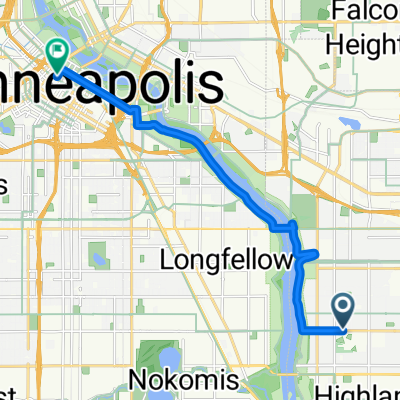
B2B00331 55417 > 55404 via Minnehaha
A cycling route starting in Mendota Heights, Minnesota, United States.
Overview
About this route
1. Take 54th St east to Minnehaha.
-
Take Minnehaha Ave bike path northwest all the way to Lake Street.
-
Cross Lake Street as Minnehaha Ave changes to 26th Ave S and continue north to 26th Street.
At this point you can either continue on 26th all the way through to Riverside and 26th. 26th is safe, but there is no bike lane. The route that is mapped is on more bike paths, as follows
-
Take a left onto 26th St. and look for the light rail trail bike path (which appears right before Hiawatha Ave).
-
Take a right onto the trail, and follow the path until it ends at 11th Avenue.
6. Take a left onto 11th, and follow the bike lane to 5th St.
7. Take a right onto 5th street. (note: 5th St is without a bike lane but traffic should be manageable. Also, veer to the left of the LRT once given the option to choose a side of the tracks).
8. Take 5th up to Portland and take a left into the bike lane.
9. Take Portland to 15th St, and take a right.
- Take 15th over the bridge and to the stoplight, where you can only turn left (because it ends in a pkg lot).
11. Turn left (onto 16th St) and follow the curve to the right. You will see your first right turn is 3rd Ave S.
12. Take a right onto 3rd Ave S which takes you to your destination. Note: Once you turn off of Portland, there are no more bike lanes on this route, but there aren't any other options unforunately. The traffic is usually manageble in this area, though, and there are wide shoulders.
Another option for step 12 is:
Continue on 16th Street to Nicollet, take a right. Take Nicollet Ave to 12th st, and turn into the bike lane there.
- -:--
- Duration
- 12.5 km
- Distance
- 15 m
- Ascent
- 12 m
- Descent
- ---
- Avg. speed
- 257 m
- Max. altitude
Route quality
Waytypes & surfaces along the route
Waytypes
Road
4 km
(32 %)
Cycleway
2.5 km
(20 %)
Surfaces
Paved
7.1 km
(57 %)
Asphalt
5.6 km
(45 %)
Concrete
1.2 km
(10 %)
Continue with Bikemap
Use, edit, or download this cycling route
You would like to ride B2B00331 55417 > 55404 via Minnehaha or customize it for your own trip? Here is what you can do with this Bikemap route:
Free features
- Save this route as favorite or in collections
- Copy & plan your own version of this route
- Sync your route with Garmin or Wahoo
Premium features
Free trial for 3 days, or one-time payment. More about Bikemap Premium.
- Navigate this route on iOS & Android
- Export a GPX / KML file of this route
- Create your custom printout (try it for free)
- Download this route for offline navigation
Discover more Premium features.
Get Bikemap PremiumFrom our community
Other popular routes starting in Mendota Heights
 River Loop
- Distance
- 15.5 km
- Ascent
- 99 m
- Descent
- 98 m
- Location
- Mendota Heights, Minnesota, United States
 B2B00191 55115>55401viaRandolph/MissBlvd/LkStBridge/WRiverPkwy/WashAv
- Distance
- 11.6 km
- Ascent
- 97 m
- Descent
- 109 m
- Location
- Mendota Heights, Minnesota, United States
 Fort Snelling Loop
- Distance
- 33.8 km
- Ascent
- 162 m
- Descent
- 164 m
- Location
- Mendota Heights, Minnesota, United States
 Snail-like route in Mendota Heights
- Distance
- 14 km
- Ascent
- 325 m
- Descent
- 325 m
- Location
- Mendota Heights, Minnesota, United States
 Mendota to Calhoun
- Distance
- 22 km
- Ascent
- 171 m
- Descent
- 132 m
- Location
- Mendota Heights, Minnesota, United States
 Big Rivers, Pilot Knob, Acadia, Valley Park, ...
- Distance
- 13.3 km
- Ascent
- 206 m
- Descent
- 206 m
- Location
- Mendota Heights, Minnesota, United States
 B2B 55116 > 55106 via Summit Ave, Kellogg Blvd E
- Distance
- 14.3 km
- Ascent
- 40 m
- Descent
- 63 m
- Location
- Mendota Heights, Minnesota, United States
 B2B00914 55116>55435 via Mend Brg, 494 bike brg, 73rd
- Distance
- 22.6 km
- Ascent
- 141 m
- Descent
- 132 m
- Location
- Mendota Heights, Minnesota, United States
Open it in the app