

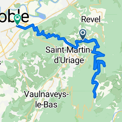
maison_Monteynard_Mure_Mens_Chichilianne
A cycling route starting in Revel, Auvergne-Rhône-Alpes, France.
Overview
About this route
variante pas faite - pas allé jusque Chichilianne arrêt à Mens
- -:--
- Duration
- 99 km
- Distance
- 1,709 m
- Ascent
- 1,376 m
- Descent
- ---
- Avg. speed
- ---
- Max. altitude

Route quality
Waytypes & surfaces along the route
Waytypes
Busy road
77.1 km
(78 %)
Quiet road
11.6 km
(12 %)
Surfaces
Paved
50.2 km
(51 %)
Asphalt
49.9 km
(50 %)
Paved (undefined)
0.2 km
(<1 %)
Continue with Bikemap
Use, edit, or download this cycling route
You would like to ride maison_Monteynard_Mure_Mens_Chichilianne or customize it for your own trip? Here is what you can do with this Bikemap route:
Free features
- Save this route as favorite or in collections
- Copy & plan your own version of this route
- Split it into stages to create a multi-day tour
- Sync your route with Garmin or Wahoo
Premium features
Free trial for 3 days, or one-time payment. More about Bikemap Premium.
- Navigate this route on iOS & Android
- Export a GPX / KML file of this route
- Create your custom printout (try it for free)
- Download this route for offline navigation
Discover more Premium features.
Get Bikemap PremiumFrom our community
Other popular routes starting in Revel
 Pinet_Chamrousse_Grenoble
- Distance
- 42.5 km
- Ascent
- 926 m
- Descent
- 1,554 m
- Location
- Revel, Auvergne-Rhône-Alpes, France
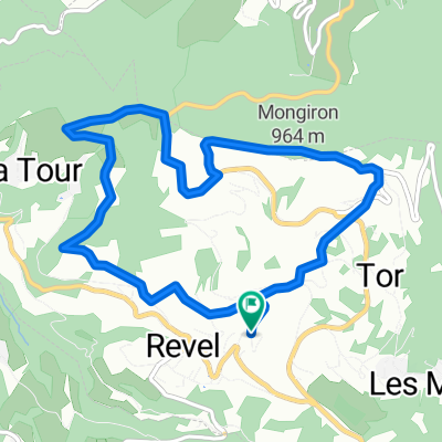 Autour des Monts - Revel
- Distance
- 8 km
- Ascent
- 369 m
- Descent
- 371 m
- Location
- Revel, Auvergne-Rhône-Alpes, France
 190728_Pérérée_dans_autre_sens
- Distance
- 46.3 km
- Ascent
- 1,888 m
- Descent
- 1,898 m
- Location
- Revel, Auvergne-Rhône-Alpes, France
 maison_Mure_Mens_Chichilianne
- Distance
- 85.4 km
- Ascent
- 1,607 m
- Descent
- 1,265 m
- Location
- Revel, Auvergne-Rhône-Alpes, France
 maison_Monteynard_Mure_Mens_Chichilianne
- Distance
- 99 km
- Ascent
- 1,709 m
- Descent
- 1,376 m
- Location
- Revel, Auvergne-Rhône-Alpes, France
 Col des Mouilles
- Distance
- 45.6 km
- Ascent
- 891 m
- Descent
- 902 m
- Location
- Revel, Auvergne-Rhône-Alpes, France
 201031_conf_1_Pinetx2
- Distance
- 16.9 km
- Ascent
- 406 m
- Descent
- 406 m
- Location
- Revel, Auvergne-Rhône-Alpes, France
 qdfg
qdfg- Distance
- 72.7 km
- Ascent
- 1,291 m
- Descent
- 1,303 m
- Location
- Revel, Auvergne-Rhône-Alpes, France
Open it in the app