

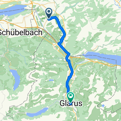
Benken-Ziegelbrücke
A cycling route starting in Benken, Canton of St. Gallen, Switzerland.
Overview
About this route
- 1 h 48 min
- Duration
- 26.6 km
- Distance
- 65 m
- Ascent
- 127 m
- Descent
- 14.8 km/h
- Avg. speed
- ---
- Max. altitude

Continue with Bikemap
Use, edit, or download this cycling route
You would like to ride Benken-Ziegelbrücke or customize it for your own trip? Here is what you can do with this Bikemap route:
Free features
- Save this route as favorite or in collections
- Copy & plan your own version of this route
- Sync your route with Garmin or Wahoo
Premium features
Free trial for 3 days, or one-time payment. More about Bikemap Premium.
- Navigate this route on iOS & Android
- Export a GPX / KML file of this route
- Create your custom printout (try it for free)
- Download this route for offline navigation
Discover more Premium features.
Get Bikemap PremiumFrom our community
Other popular routes starting in Benken
 satteleg
- Distance
- 66.3 km
- Ascent
- 1,123 m
- Descent
- 1,122 m
- Location
- Benken, Canton of St. Gallen, Switzerland
 hirzli
- Distance
- 42.6 km
- Ascent
- 1,033 m
- Descent
- 1,119 m
- Location
- Benken, Canton of St. Gallen, Switzerland
 Arbeitsweg
- Distance
- 23.8 km
- Ascent
- 139 m
- Descent
- 103 m
- Location
- Benken, Canton of St. Gallen, Switzerland
 Benken-Wald-Girenbad-Gibswil-Wald-Benken
- Distance
- 51.7 km
- Ascent
- 659 m
- Descent
- 661 m
- Location
- Benken, Canton of St. Gallen, Switzerland
 ernetschwil-uetliburg-riedern- kaltbrunn 👍
- Distance
- 30.9 km
- Ascent
- 780 m
- Descent
- 774 m
- Location
- Benken, Canton of St. Gallen, Switzerland
 Atzmännig
- Distance
- 37.1 km
- Ascent
- 560 m
- Descent
- 560 m
- Location
- Benken, Canton of St. Gallen, Switzerland
 Arbeitsweg 😜
- Distance
- 23.1 km
- Ascent
- 257 m
- Descent
- 168 m
- Location
- Benken, Canton of St. Gallen, Switzerland
 Benken-Ziegelbrücke
- Distance
- 26.6 km
- Ascent
- 65 m
- Descent
- 127 m
- Location
- Benken, Canton of St. Gallen, Switzerland
Open it in the app