Flachetappe Aufenauer Höhe
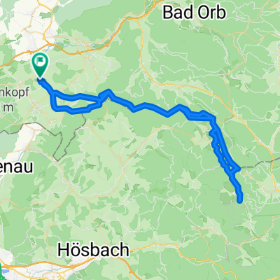
A cycling route starting in Gelnhausen, Hesse, Germany.
Overview
About this route
Starting in Haitz, the route first heads towards Wächtersbach and from there to Bad Orb. From there, it goes through the Autal valley up to the Aufenau Heights. It then continues through Aufenau onto the railway bike path and back to Haitz via Wächtersbach.
Best view: Aufenau Heights overlooking Wächtersbach
- -:--
- Duration
- 30.5 km
- Distance
- 202 m
- Ascent
- 201 m
- Descent
- ---
- Avg. speed
- ---
- Max. altitude
Route quality
Waytypes & surfaces along the route
Waytypes
Track
19.5 km
(64 %)
Quiet road
3.7 km
(12 %)
Surfaces
Paved
29.3 km
(96 %)
Asphalt
25.9 km
(85 %)
Paved (undefined)
1.8 km
(6 %)
Route highlights
Points of interest along the route
Point of interest after 30.5 km
Start Schöne Aussicht
Continue with Bikemap
Use, edit, or download this cycling route
You would like to ride Flachetappe Aufenauer Höhe or customize it for your own trip? Here is what you can do with this Bikemap route:
Free features
- Save this route as favorite or in collections
- Copy & plan your own version of this route
- Sync your route with Garmin or Wahoo
Premium features
Free trial for 3 days, or one-time payment. More about Bikemap Premium.
- Navigate this route on iOS & Android
- Export a GPX / KML file of this route
- Create your custom printout (try it for free)
- Download this route for offline navigation
Discover more Premium features.
Get Bikemap PremiumFrom our community
Other popular routes starting in Gelnhausen
- Flachetappe Aufenauer Höhe
- Distance
- 30.5 km
- Ascent
- 202 m
- Descent
- 201 m
- Location
- Gelnhausen, Hesse, Germany
- Querenberg
- Distance
- 56.9 km
- Ascent
- 738 m
- Descent
- 725 m
- Location
- Gelnhausen, Hesse, Germany
- Wiebüttsee.gpx
- Distance
- 50.1 km
- Ascent
- 579 m
- Descent
- 585 m
- Location
- Gelnhausen, Hesse, Germany
- Wolferborn
- Distance
- 59.6 km
- Ascent
- 510 m
- Descent
- 510 m
- Location
- Gelnhausen, Hesse, Germany
- Kahl am Main
- Distance
- 55.8 km
- Ascent
- 150 m
- Descent
- 118 m
- Location
- Gelnhausen, Hesse, Germany
- Alzenau-Kahl-Rodenbach
- Distance
- 47.1 km
- Ascent
- 283 m
- Descent
- 279 m
- Location
- Gelnhausen, Hesse, Germany
- Lieblos-Hammersbach Trainingsrunde
- Distance
- 52 km
- Ascent
- 344 m
- Descent
- 357 m
- Location
- Gelnhausen, Hesse, Germany
- Spessart*20*36km+1041hm
- Distance
- 35.4 km
- Ascent
- 768 m
- Descent
- 771 m
- Location
- Gelnhausen, Hesse, Germany
Open it in the app