

2018_07_13_MTB_Groß-Heubach_36km_930hm
A cycling route starting in Großheubach, Bavaria, Germany.
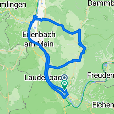
Overview
About this route
Parking: Großheubach, Hofwiese (Lunapark)
36 km and 930 m of elevation gain
- -:--
- Duration
- 36.4 km
- Distance
- 849 m
- Ascent
- 847 m
- Descent
- ---
- Avg. speed
- ---
- Max. altitude
Route quality
Waytypes & surfaces along the route
Waytypes
Track
24.4 km
(67 %)
Path
6.2 km
(17 %)
Surfaces
Paved
6.9 km
(19 %)
Unpaved
28.4 km
(78 %)
Gravel
14.9 km
(41 %)
Ground
12 km
(33 %)
Continue with Bikemap
Use, edit, or download this cycling route
You would like to ride 2018_07_13_MTB_Groß-Heubach_36km_930hm or customize it for your own trip? Here is what you can do with this Bikemap route:
Free features
- Save this route as favorite or in collections
- Copy & plan your own version of this route
- Sync your route with Garmin or Wahoo
Premium features
Free trial for 3 days, or one-time payment. More about Bikemap Premium.
- Navigate this route on iOS & Android
- Export a GPX / KML file of this route
- Create your custom printout (try it for free)
- Download this route for offline navigation
Discover more Premium features.
Get Bikemap PremiumFrom our community
Other popular routes starting in Großheubach
 Maintalhöhenweg Teil 2
- Distance
- 45.7 km
- Ascent
- 970 m
- Descent
- 952 m
- Location
- Großheubach, Bavaria, Germany
 Großheubach nach Mosbach
- Distance
- 68.3 km
- Ascent
- 557 m
- Descent
- 519 m
- Location
- Großheubach, Bavaria, Germany
 Trainingsrunde Morettriathlon
- Distance
- 79.9 km
- Ascent
- 767 m
- Descent
- 778 m
- Location
- Großheubach, Bavaria, Germany
 2 Mainbrücken Halbmarathon
- Distance
- 20.6 km
- Ascent
- 67 m
- Descent
- 86 m
- Location
- Großheubach, Bavaria, Germany
 Tagestour 2 Großheubach - Mainz
- Distance
- 123.2 km
- Ascent
- 244 m
- Descent
- 277 m
- Location
- Großheubach, Bavaria, Germany
 28.05.12 Odenwaldtour
- Distance
- 122.2 km
- Ascent
- 760 m
- Descent
- 760 m
- Location
- Großheubach, Bavaria, Germany
 Spessart-1
- Distance
- 50.5 km
- Ascent
- 427 m
- Descent
- 427 m
- Location
- Großheubach, Bavaria, Germany
 Dompfaffenweg nach Hauptstraße
- Distance
- 63.9 km
- Ascent
- 732 m
- Descent
- 758 m
- Location
- Großheubach, Bavaria, Germany
Open it in the app