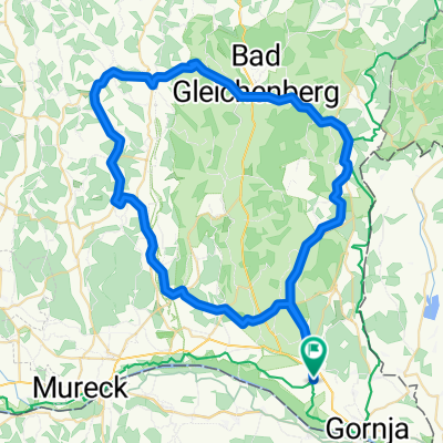
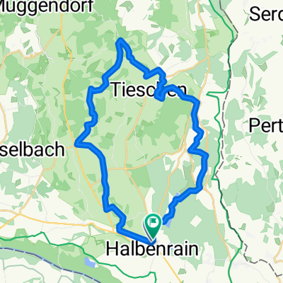
GRENZLAND-TOUR Süd-Ost Steiermark
A cycling route starting in Halbenrain, Styria, Austria.
Overview
About this route
- 3 h 57 min
- Duration
- 56.1 km
- Distance
- 362 m
- Ascent
- 368 m
- Descent
- 14.2 km/h
- Avg. speed
- ---
- Avg. speed
Route photos
Route quality
Waytypes & surfaces along the route
Waytypes
Quiet road
28.1 km
(50 %)
Road
9.8 km
(17 %)
Surfaces
Paved
47.1 km
(84 %)
Unpaved
2.9 km
(5 %)
Asphalt
46.9 km
(84 %)
Gravel
2 km
(4 %)
Continue with Bikemap
Use, edit, or download this cycling route
You would like to ride GRENZLAND-TOUR Süd-Ost Steiermark or customize it for your own trip? Here is what you can do with this Bikemap route:
Free features
- Save this route as favorite or in collections
- Copy & plan your own version of this route
- Sync your route with Garmin or Wahoo
Premium features
Free trial for 3 days, or one-time payment. More about Bikemap Premium.
- Navigate this route on iOS & Android
- Export a GPX / KML file of this route
- Create your custom printout (try it for free)
- Download this route for offline navigation
Discover more Premium features.
Get Bikemap PremiumFrom our community
Other popular routes starting in Halbenrain
- Dietzen 76, Halbenrain nach Dietzen 74
- Distance
- 28 km
- Ascent
- 229 m
- Descent
- 273 m
- Location
- Halbenrain, Styria, Austria
- Oberpurkla Krusdorf Öedt Felbach Perlsdorf Gnas Oberpurkla
- Distance
- 68 km
- Ascent
- 358 m
- Descent
- 359 m
- Location
- Halbenrain, Styria, Austria
- GRENZLAND-TOUR Süd-Ost Steiermark
- Distance
- 56.1 km
- Ascent
- 362 m
- Descent
- 368 m
- Location
- Halbenrain, Styria, Austria
- Oberpurkla Krusdorf Öedt Felbach Perlsdorf Gnas Oberpurkla
- Distance
- 68 km
- Ascent
- 365 m
- Descent
- 365 m
- Location
- Halbenrain, Styria, Austria
- Gleisdorf St. Anna Oberpurkla
- Distance
- 70.9 km
- Ascent
- 363 m
- Descent
- 244 m
- Location
- Halbenrain, Styria, Austria
- Oberpurkla 68, Halbenrain to Ratschendorf 42, Ratschendorf
- Distance
- 12.2 km
- Ascent
- 29 m
- Descent
- 23 m
- Location
- Halbenrain, Styria, Austria
- Südoststeiermark Runde mit toller Aussicht
- Distance
- 58.2 km
- Ascent
- 300 m
- Descent
- 297 m
- Location
- Halbenrain, Styria, Austria
- 2 HaRai - Boreci - Jeruzalem - Bad Radkersburg - HaRai 🇸🇮
- Distance
- 102.9 km
- Ascent
- 781 m
- Descent
- 787 m
- Location
- Halbenrain, Styria, Austria
Open it in the app