

Altdorf - Göscheneralp
A cycling route starting in Altdorf, Canton of Uri, Switzerland.
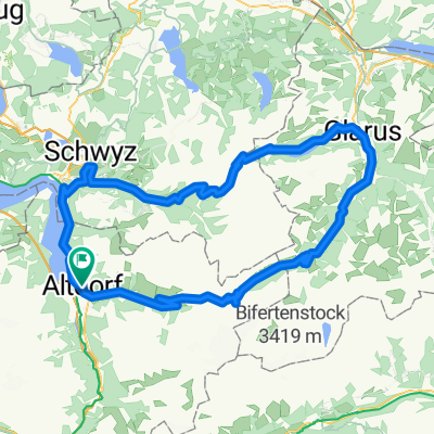
Overview
About this route
From Altdorf, follow Bahnhof- or Attinghauserstrasse to the Reuss bridge in Attinghausen. Here, switch to the
eastern Wuhrweg and ride along the Reuss to the Reuss bridge. After crossing the bridge, follow the side road,
passing by idyllic farms and cozy spots along the Reuss, through Wiler and Butzen to Amsteg. There you will find the
impressive railway bridge over the Chärstelenbach.
The varied tour continues with a short climb onto the Gotthard mule track. Passing the avalanche protection niches of 'Brisch Laui', you ride to Meitschligen. From the eastern valley flank between Gurtnellen and
Wassen, you can get excellent views of trains snaking up the upper Reuss valley over bridges, viaducts, and hairpin tunnels.
Behind Wattingen, you pass under the canopy of the St. Joseph chapel, built in the last quarter of the 18th century. The route continues along a magnificent forest path via Neiselental to the railway village of Göschenen.
The final section of the tour leads you into the fascinating Göscheneralp valley. On the so-called Jeep Weg, you ride a beautifully laid-out path with a pleasant incline along the Göschener Reuss. Over the mountain road, which snakes elegantly through the wild rocky landscape, you reach the tour's destination, the dam crest of the impressive Göscheneralp reservoir.
- -:--
- Duration
- 40.1 km
- Distance
- 1,384 m
- Ascent
- 50 m
- Descent
- ---
- Avg. speed
- ---
- Max. altitude

Continue with Bikemap
Use, edit, or download this cycling route
You would like to ride Altdorf - Göscheneralp or customize it for your own trip? Here is what you can do with this Bikemap route:
Free features
- Save this route as favorite or in collections
- Copy & plan your own version of this route
- Sync your route with Garmin or Wahoo
Premium features
Free trial for 3 days, or one-time payment. More about Bikemap Premium.
- Navigate this route on iOS & Android
- Export a GPX / KML file of this route
- Create your custom printout (try it for free)
- Download this route for offline navigation
Discover more Premium features.
Get Bikemap PremiumFrom our community
Other popular routes starting in Altdorf
 008 Altdorf - Willerzell, SA 01.08.20
- Distance
- 47.7 km
- Ascent
- 905 m
- Descent
- 473 m
- Location
- Altdorf, Canton of Uri, Switzerland
 Altdorf Unterschächen
- Distance
- 12.7 km
- Ascent
- 608 m
- Descent
- 61 m
- Location
- Altdorf, Canton of Uri, Switzerland
 klausen pass Pragel pass
- Distance
- 130.4 km
- Ascent
- 2,809 m
- Descent
- 2,809 m
- Location
- Altdorf, Canton of Uri, Switzerland
 Isenthal Bike - 403 SchweizMobil
- Distance
- 34.2 km
- Ascent
- 1,582 m
- Descent
- 1,396 m
- Location
- Altdorf, Canton of Uri, Switzerland
 Klausenpass_Pragelpass
- Distance
- 130.9 km
- Ascent
- 2,641 m
- Descent
- 2,641 m
- Location
- Altdorf, Canton of Uri, Switzerland
 Altdorf-Klausenpass (1948m)
- Distance
- 25.1 km
- Ascent
- 1,579 m
- Descent
- 122 m
- Location
- Altdorf, Canton of Uri, Switzerland
 Ibergeregg-Pragel-Klausen
- Distance
- 142.1 km
- Ascent
- 3,373 m
- Descent
- 3,373 m
- Location
- Altdorf, Canton of Uri, Switzerland
 Ibergeregg-Pragel-Klausen
- Distance
- 142.1 km
- Ascent
- 3,364 m
- Descent
- 3,363 m
- Location
- Altdorf, Canton of Uri, Switzerland
Open it in the app