
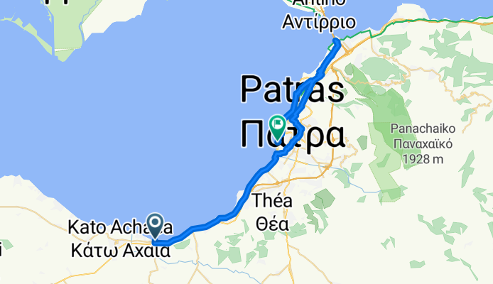
Patras
A cycling route starting in Káto Achaḯa, West Greece, Greece.
Overview
About this route
Kamp Alssos- Rio Pio - Patras
- -:--
- Duration
- 43.3 km
- Distance
- 106 m
- Ascent
- 115 m
- Descent
- ---
- Avg. speed
- ---
- Max. altitude

Route quality
Waytypes & surfaces along the route
Waytypes
Quiet road
18.6 km
(43 %)
Road
10.8 km
(25 %)
Surfaces
Paved
25.5 km
(59 %)
Unpaved
0.4 km
(1 %)
Asphalt
25.5 km
(59 %)
Gravel
0.4 km
(1 %)
Undefined
17.3 km
(40 %)
Continue with Bikemap
Use, edit, or download this cycling route
You would like to ride Patras or customize it for your own trip? Here is what you can do with this Bikemap route:
Free features
- Save this route as favorite or in collections
- Copy & plan your own version of this route
- Sync your route with Garmin or Wahoo
Premium features
Free trial for 3 days, or one-time payment. More about Bikemap Premium.
- Navigate this route on iOS & Android
- Export a GPX / KML file of this route
- Create your custom printout (try it for free)
- Download this route for offline navigation
Discover more Premium features.
Get Bikemap PremiumFrom our community
Other popular routes starting in Káto Achaḯa
 GR_02
GR_02- Distance
- 77.8 km
- Ascent
- 620 m
- Descent
- 601 m
- Location
- Káto Achaḯa, West Greece, Greece
 Patras
- Distance
- 43.3 km
- Ascent
- 106 m
- Descent
- 115 m
- Location
- Káto Achaḯa, West Greece, Greece
 Peloponnes 12-19 (Camping Kato Alissos - Patras)
- Distance
- 29.3 km
- Ascent
- 99 m
- Descent
- 106 m
- Location
- Káto Achaḯa, West Greece, Greece
 Gialos nach Vartholomio
- Distance
- 68.1 km
- Ascent
- 296 m
- Descent
- 302 m
- Location
- Káto Achaḯa, West Greece, Greece
 Gialos nach Paralia
- Distance
- 67.7 km
- Ascent
- 296 m
- Descent
- 305 m
- Location
- Káto Achaḯa, West Greece, Greece
Open it in the app