

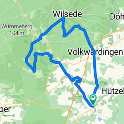
Bispingen-Steinbeck-Volkwardingen-Totengrund-Bispingen
A cycling route starting in Bispingen, Lower Saxony, Germany.
Overview
About this route
- -:--
- Duration
- 27.3 km
- Distance
- 145 m
- Ascent
- 148 m
- Descent
- ---
- Avg. speed
- ---
- Max. altitude

Route quality
Waytypes & surfaces along the route
Waytypes
Quiet road
10.1 km
(37 %)
Track
8.5 km
(31 %)
Surfaces
Paved
10.4 km
(38 %)
Unpaved
11.9 km
(44 %)
Asphalt
6.4 km
(23 %)
Ground
5 km
(18 %)
Continue with Bikemap
Use, edit, or download this cycling route
You would like to ride Bispingen-Steinbeck-Volkwardingen-Totengrund-Bispingen or customize it for your own trip? Here is what you can do with this Bikemap route:
Free features
- Save this route as favorite or in collections
- Copy & plan your own version of this route
- Sync your route with Garmin or Wahoo
Premium features
Free trial for 3 days, or one-time payment. More about Bikemap Premium.
- Navigate this route on iOS & Android
- Export a GPX / KML file of this route
- Create your custom printout (try it for free)
- Download this route for offline navigation
Discover more Premium features.
Get Bikemap PremiumFrom our community
Other popular routes starting in Bispingen
 Von Behringen durch die Lüneburger Heide nach Wilsede
- Distance
- 13.8 km
- Ascent
- 118 m
- Descent
- 118 m
- Location
- Bispingen, Lower Saxony, Germany
 Ausflug nach Wilsede😎
- Distance
- 11.5 km
- Ascent
- 95 m
- Descent
- 52 m
- Location
- Bispingen, Lower Saxony, Germany
 Schnuckentour
- Distance
- 31.2 km
- Ascent
- 161 m
- Descent
- 161 m
- Location
- Bispingen, Lower Saxony, Germany
 Wd07-Pietzmoor-Osterheide-53km
- Distance
- 53.2 km
- Ascent
- 361 m
- Descent
- 359 m
- Location
- Bispingen, Lower Saxony, Germany
 Wd06-Kleine-Heidetour-27km
- Distance
- 27.2 km
- Ascent
- 204 m
- Descent
- 196 m
- Location
- Bispingen, Lower Saxony, Germany
 gut2 bispingen
- Distance
- 19.5 km
- Ascent
- 111 m
- Descent
- 109 m
- Location
- Bispingen, Lower Saxony, Germany
 Bispingen-Schwindequelle
- Distance
- 31.9 km
- Ascent
- 120 m
- Descent
- 119 m
- Location
- Bispingen, Lower Saxony, Germany
 Bispingen-Steinbeck-Volkwardingen-Totengrund-Bispingen
- Distance
- 27.3 km
- Ascent
- 145 m
- Descent
- 148 m
- Location
- Bispingen, Lower Saxony, Germany
Open it in the app