

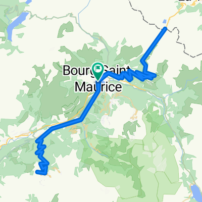
CORMET DE ROSELEND (por Bourg-Saint-Maurice)
A cycling route starting in Bourg-Saint-Maurice, Auvergne-Rhône-Alpes, France.
Overview
About this route
- -:--
- Duration
- 20.1 km
- Distance
- 1,198 m
- Ascent
- 70 m
- Descent
- ---
- Avg. speed
- ---
- Max. altitude

Route quality
Waytypes & surfaces along the route
Surfaces
Paved
11 km
(55 %)
Asphalt
11 km
(55 %)
Undefined
9 km
(45 %)
Continue with Bikemap
Use, edit, or download this cycling route
You would like to ride CORMET DE ROSELEND (por Bourg-Saint-Maurice) or customize it for your own trip? Here is what you can do with this Bikemap route:
Free features
- Save this route as favorite or in collections
- Copy & plan your own version of this route
- Sync your route with Garmin or Wahoo
Premium features
Free trial for 3 days, or one-time payment. More about Bikemap Premium.
- Navigate this route on iOS & Android
- Export a GPX / KML file of this route
- Create your custom printout (try it for free)
- Download this route for offline navigation
Discover more Premium features.
Get Bikemap PremiumFrom our community
Other popular routes starting in Bourg-Saint-Maurice
 2017 ALPS Etapa 4 - Cormet de Roselend
- Distance
- 93.2 km
- Ascent
- 2,244 m
- Descent
- 2,519 m
- Location
- Bourg-Saint-Maurice, Auvergne-Rhône-Alpes, France
 Jovet
Jovet- Distance
- 92 km
- Ascent
- 2,026 m
- Descent
- 2,026 m
- Location
- Bourg-Saint-Maurice, Auvergne-Rhône-Alpes, France
 Day 8 - Bourg Saint Maurice, Iseran - 94 Km / 2300 m
- Distance
- 94.2 km
- Ascent
- 2,989 m
- Descent
- 2,990 m
- Location
- Bourg-Saint-Maurice, Auvergne-Rhône-Alpes, France
 2017 ALPS Col de l'Iseran a
- Distance
- 147.7 km
- Ascent
- 3,138 m
- Descent
- 3,138 m
- Location
- Bourg-Saint-Maurice, Auvergne-Rhône-Alpes, France
 2017 Roselend 2
- Distance
- 113.9 km
- Ascent
- 2,681 m
- Descent
- 2,467 m
- Location
- Bourg-Saint-Maurice, Auvergne-Rhône-Alpes, France
 2017 roselend -saisies
- Distance
- 109.3 km
- Ascent
- 2,545 m
- Descent
- 2,331 m
- Location
- Bourg-Saint-Maurice, Auvergne-Rhône-Alpes, France
 RdGA 2022 - Tag 3
- Distance
- 120.5 km
- Ascent
- 2,888 m
- Descent
- 2,979 m
- Location
- Bourg-Saint-Maurice, Auvergne-Rhône-Alpes, France
 2017 ALPS Etapa 2 - La plagne
- Distance
- 120 km
- Ascent
- 2,737 m
- Descent
- 2,737 m
- Location
- Bourg-Saint-Maurice, Auvergne-Rhône-Alpes, France
Open it in the app