

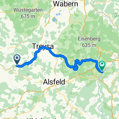
Anzefahr-Elbesberg -Sosenberg -Müncheberg
A cycling route starting in Stadtallendorf, Hesse, Germany.
Overview
About this route
- -:--
- Duration
- 50.3 km
- Distance
- 556 m
- Ascent
- 556 m
- Descent
- ---
- Avg. speed
- ---
- Max. altitude

Route quality
Waytypes & surfaces along the route
Waytypes
Track
31.7 km
(63 %)
Quiet road
15.1 km
(30 %)
Surfaces
Paved
29.2 km
(58 %)
Unpaved
18.6 km
(37 %)
Asphalt
28.7 km
(57 %)
Gravel
14.6 km
(29 %)
Continue with Bikemap
Use, edit, or download this cycling route
You would like to ride Anzefahr-Elbesberg -Sosenberg -Müncheberg or customize it for your own trip? Here is what you can do with this Bikemap route:
Free features
- Save this route as favorite or in collections
- Copy & plan your own version of this route
- Sync your route with Garmin or Wahoo
Premium features
Free trial for 3 days, or one-time payment. More about Bikemap Premium.
- Navigate this route on iOS & Android
- Export a GPX / KML file of this route
- Create your custom printout (try it for free)
- Download this route for offline navigation
Discover more Premium features.
Get Bikemap PremiumFrom our community
Other popular routes starting in Stadtallendorf
 Stadtallendorf - Niederaula
- Distance
- 70.2 km
- Ascent
- 596 m
- Descent
- 614 m
- Location
- Stadtallendorf, Hesse, Germany
 Stadtallendorf, Stadtallendorf nach Stadtallendorf, Stadtallendorf
- Distance
- 26.2 km
- Ascent
- 225 m
- Descent
- 220 m
- Location
- Stadtallendorf, Hesse, Germany
 Stadtallendorf - Kreuzberg
- Distance
- 110.9 km
- Ascent
- 1,210 m
- Descent
- 609 m
- Location
- Stadtallendorf, Hesse, Germany
 Wetzlarer Straße 10, Stadtallendorf nach Wetzlarer Straße 10, Stadtallendorf
- Distance
- 28.6 km
- Ascent
- 355 m
- Descent
- 351 m
- Location
- Stadtallendorf, Hesse, Germany
 Rund um den Senberg
- Distance
- 53.5 km
- Ascent
- 472 m
- Descent
- 472 m
- Location
- Stadtallendorf, Hesse, Germany
 Ausfahrt vom 26. Juni, 18:53
- Distance
- 12.6 km
- Ascent
- 167 m
- Descent
- 166 m
- Location
- Stadtallendorf, Hesse, Germany
 Gießener Straße 25, Stadtallendorf nach Wetzlarer Straße 10, Stadtallendorf
- Distance
- 30.7 km
- Ascent
- 525 m
- Descent
- 533 m
- Location
- Stadtallendorf, Hesse, Germany
 Georgsteich
- Distance
- 24.3 km
- Ascent
- 326 m
- Descent
- 326 m
- Location
- Stadtallendorf, Hesse, Germany
Open it in the app