

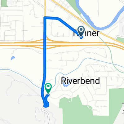
Thither to Snoqualmie
A cycling route starting in Tanner, Washington, United States of America.
Overview
About this route
- -:--
- Duration
- 23 km
- Distance
- 46 m
- Ascent
- 46 m
- Descent
- ---
- Avg. speed
- ---
- Max. altitude

Route quality
Waytypes & surfaces along the route
Waytypes
Quiet road
7.1 km
(31 %)
Cycleway
5 km
(22 %)
Surfaces
Paved
9.5 km
(41 %)
Unpaved
4 km
(17 %)
Asphalt
8.6 km
(37 %)
Gravel
3.8 km
(16 %)
Continue with Bikemap
Use, edit, or download this cycling route
You would like to ride Thither to Snoqualmie or customize it for your own trip? Here is what you can do with this Bikemap route:
Free features
- Save this route as favorite or in collections
- Copy & plan your own version of this route
- Sync your route with Garmin or Wahoo
Premium features
Free trial for 3 days, or one-time payment. More about Bikemap Premium.
- Navigate this route on iOS & Android
- Export a GPX / KML file of this route
- Create your custom printout (try it for free)
- Download this route for offline navigation
Discover more Premium features.
Get Bikemap PremiumFrom our community
Other popular routes starting in Tanner
 Thither to Snoqualmie
- Distance
- 23 km
- Ascent
- 46 m
- Descent
- 46 m
- Location
- Tanner, Washington, United States of America
 Shayna
- Distance
- 2.7 km
- Ascent
- 35 m
- Descent
- 47 m
- Location
- Tanner, Washington, United States of America
 Snoqualmie pass climb
- Distance
- 85 km
- Ascent
- 2,546 m
- Descent
- 2,543 m
- Location
- Tanner, Washington, United States of America
 gravel parking to rattlesnake
- Distance
- 10.6 km
- Ascent
- 171 m
- Descent
- 33 m
- Location
- Tanner, Washington, United States of America
 Snoqualmie Valley Trail, North Bend to 44475–44499 SE Tanner Rd, North Bend
- Distance
- 19 km
- Ascent
- 414 m
- Descent
- 413 m
- Location
- Tanner, Washington, United States of America
 Route to 4552 34th Ave S, Seattle
- Distance
- 81.3 km
- Ascent
- 1,126 m
- Descent
- 1,435 m
- Location
- Tanner, Washington, United States of America
 Route to 47487–47599 SE 159th St, North Bend
- Distance
- 2.7 km
- Ascent
- 44 m
- Descent
- 65 m
- Location
- Tanner, Washington, United States of America
Open it in the app