

180722_R_Gammertingen-Tübingen
A cycling route starting in Gammertingen, Baden-Wurttemberg, Germany.
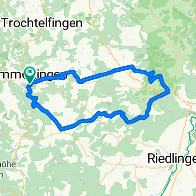
Overview
About this route
First on the Zollernalb up to just before Honau, then down to Honau to the Echaz spring, from there to the Echaz mouth at Kirchentellinsfurt into the Neckar and finally flat along the Neckar to Tübingen to the train station.
- -:--
- Duration
- 58.1 km
- Distance
- 165 m
- Ascent
- 520 m
- Descent
- ---
- Avg. speed
- ---
- Max. altitude

Route quality
Waytypes & surfaces along the route
Waytypes
Track
15.7 km
(27 %)
Quiet road
15.1 km
(26 %)
Surfaces
Paved
48.8 km
(84 %)
Unpaved
2.9 km
(5 %)
Asphalt
46.5 km
(80 %)
Concrete
1.7 km
(3 %)
Continue with Bikemap
Use, edit, or download this cycling route
You would like to ride 180722_R_Gammertingen-Tübingen or customize it for your own trip? Here is what you can do with this Bikemap route:
Free features
- Save this route as favorite or in collections
- Copy & plan your own version of this route
- Sync your route with Garmin or Wahoo
Premium features
Free trial for 3 days, or one-time payment. More about Bikemap Premium.
- Navigate this route on iOS & Android
- Export a GPX / KML file of this route
- Create your custom printout (try it for free)
- Download this route for offline navigation
Discover more Premium features.
Get Bikemap PremiumFrom our community
Other popular routes starting in Gammertingen
 Gammertingen - Zwiefalten
- Distance
- 53.6 km
- Ascent
- 525 m
- Descent
- 525 m
- Location
- Gammertingen, Baden-Wurttemberg, Germany
 7th Century of 2020 Part 2 April 27
- Distance
- 83.6 km
- Ascent
- 707 m
- Descent
- 1,003 m
- Location
- Gammertingen, Baden-Wurttemberg, Germany
 Meine 1. Runde mit dem neuen Crosser
- Distance
- 16.8 km
- Ascent
- 286 m
- Descent
- 287 m
- Location
- Gammertingen, Baden-Wurttemberg, Germany
 180722_R_Gammertingen-Tübingen
- Distance
- 58.1 km
- Ascent
- 165 m
- Descent
- 520 m
- Location
- Gammertingen, Baden-Wurttemberg, Germany
 29th Century of 2020 November 2 Part 2
- Distance
- 71.4 km
- Ascent
- 509 m
- Descent
- 456 m
- Location
- Gammertingen, Baden-Wurttemberg, Germany
 Gammertingen-Trochtelfingen
- Distance
- 21.5 km
- Ascent
- 219 m
- Descent
- 219 m
- Location
- Gammertingen, Baden-Wurttemberg, Germany
 Schöne Trails um Gammertingen
- Distance
- 66.5 km
- Ascent
- 797 m
- Descent
- 796 m
- Location
- Gammertingen, Baden-Wurttemberg, Germany
 Gammertingen Lauchert Runde
- Distance
- 38.3 km
- Ascent
- 363 m
- Descent
- 354 m
- Location
- Gammertingen, Baden-Wurttemberg, Germany
Open it in the app