

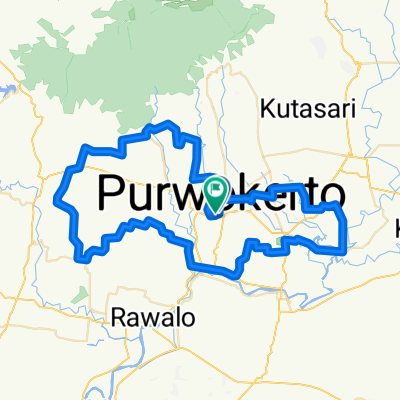
GCPI Rute Kota 2
A cycling route starting in Purwokerto, Central Java, Indonesia.
Overview
About this route
Car Free Day Snday Morning GCPI Route
Minggu 22 Juli 2018
- -:--
- Duration
- 16.1 km
- Distance
- 88 m
- Ascent
- 90 m
- Descent
- ---
- Avg. speed
- ---
- Max. altitude

Route quality
Waytypes & surfaces along the route
Waytypes
Road
11.3 km
(70 %)
Quiet road
2.9 km
(18 %)
Surfaces
Paved
14 km
(87 %)
Asphalt
14 km
(87 %)
Undefined
2.1 km
(13 %)
Continue with Bikemap
Use, edit, or download this cycling route
You would like to ride GCPI Rute Kota 2 or customize it for your own trip? Here is what you can do with this Bikemap route:
Free features
- Save this route as favorite or in collections
- Copy & plan your own version of this route
- Sync your route with Garmin or Wahoo
Premium features
Free trial for 3 days, or one-time payment. More about Bikemap Premium.
- Navigate this route on iOS & Android
- Export a GPX / KML file of this route
- Create your custom printout (try it for free)
- Download this route for offline navigation
Discover more Premium features.
Get Bikemap PremiumFrom our community
Other popular routes starting in Purwokerto
 GCPI Rute Kota 2
- Distance
- 16.1 km
- Ascent
- 88 m
- Descent
- 90 m
- Location
- Purwokerto, Central Java, Indonesia
 Afternoon City Road Bike
- Distance
- 20.8 km
- Ascent
- 104 m
- Descent
- 103 m
- Location
- Purwokerto, Central Java, Indonesia
 PWT - KBM
- Distance
- 59.6 km
- Ascent
- 915 m
- Descent
- 1,013 m
- Location
- Purwokerto, Central Java, Indonesia
 PUCC 100K Final
- Distance
- 105.8 km
- Ascent
- 795 m
- Descent
- 797 m
- Location
- Purwokerto, Central Java, Indonesia
 Beji - Alun-alun
- Distance
- 15.6 km
- Ascent
- 90 m
- Descent
- 93 m
- Location
- Purwokerto, Central Java, Indonesia
 Baiti Jannati Sunday Cycling
- Distance
- 25 km
- Ascent
- 295 m
- Descent
- 292 m
- Location
- Purwokerto, Central Java, Indonesia
 Baturxtraden Mei 2022
- Distance
- 32.5 km
- Ascent
- 938 m
- Descent
- 933 m
- Location
- Purwokerto, Central Java, Indonesia
 Pasir Indah-Baturaden via Kemutug
- Distance
- 35.2 km
- Ascent
- 674 m
- Descent
- 667 m
- Location
- Purwokerto, Central Java, Indonesia
Open it in the app