
Mrcina - 52 - Enduro
A cycling route starting in Kašina, City of Zagreb, Croatia.
Overview
About this route
WATCH OUT FOR HIKERS on these trails!!!
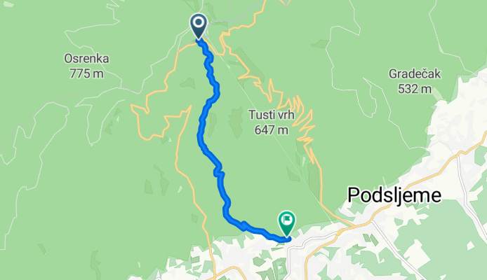
One of my favourite routes. Starts from the road on the top of the mountain (after the bus stop, 10m on the left, near the fence). Starts as a very narrow and steep singletrack that ends on a dirt road but after 5m you continue on the singletrack until you get to a short and punchy climb you get to a gravel road on which you have a fast and wide dirt road (stick to the right, do not climb the hill in front of you). After 100-200m you must not miss a short entrance to a singletrack path again (trail number 52). After a short singletrack you return again to a dirt wide road then again after 100-200m you stick to the left and look for an entrance to a short singletrack which connects you with enduro trail "Opušteno" until the end.
WATCH OUT FOR HIKERS ON TRAIL 52!!
- -:--
- Duration
- 6.4 km
- Distance
- 71 m
- Ascent
- 763 m
- Descent
- ---
- Avg. speed
- ---
- Max. altitude

Continue with Bikemap
Use, edit, or download this cycling route
You would like to ride Mrcina - 52 - Enduro or customize it for your own trip? Here is what you can do with this Bikemap route:
Free features
- Save this route as favorite or in collections
- Copy & plan your own version of this route
- Sync your route with Garmin or Wahoo
Premium features
Free trial for 3 days, or one-time payment. More about Bikemap Premium.
- Navigate this route on iOS & Android
- Export a GPX / KML file of this route
- Create your custom printout (try it for free)
- Download this route for offline navigation
Discover more Premium features.
Get Bikemap PremiumFrom our community
Other popular routes starting in Kašina
 Sljeme - Enduro 1
- Distance
- 6.1 km
- Ascent
- 75 m
- Descent
- 790 m
- Location
- Kašina, City of Zagreb, Croatia
 Sljeme 1 (Markuševec - Goroščica - Markuševac)
- Distance
- 22.4 km
- Ascent
- 682 m
- Descent
- 680 m
- Location
- Kašina, City of Zagreb, Croatia
 MC Trail
- Distance
- 5.5 km
- Ascent
- 37 m
- Descent
- 655 m
- Location
- Kašina, City of Zagreb, Croatia
 Sljeme staza 57 - Gips - zaobilazak desno - Požgaj - prvi stup žičare - Lonjščina
- Distance
- 6.5 km
- Ascent
- 68 m
- Descent
- 781 m
- Location
- Kašina, City of Zagreb, Croatia
 Sljeme - staza 69
- Distance
- 7.9 km
- Ascent
- 159 m
- Descent
- 781 m
- Location
- Kašina, City of Zagreb, Croatia
 Sljeme staza 26-9-10 - Tomislavac - Grafičar - Vrapče
- Distance
- 11.1 km
- Ascent
- 106 m
- Descent
- 870 m
- Location
- Kašina, City of Zagreb, Croatia
 Sljemenska planinarska staza 12
- Distance
- 6.6 km
- Ascent
- 119 m
- Descent
- 851 m
- Location
- Kašina, City of Zagreb, Croatia
 Sljeme - staza 20
- Distance
- 6.6 km
- Ascent
- 708 m
- Descent
- 125 m
- Location
- Kašina, City of Zagreb, Croatia
Open it in the app