

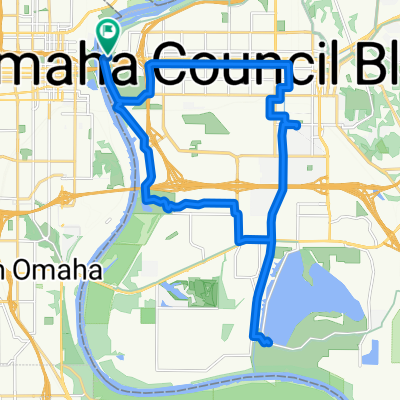
North on Keystone/South on Big Papio
A cycling route starting in Omaha, Nebraska, United States.
Overview
About this route
21.2 miles from Katie and Jimmy's house
- -:--
- Duration
- 34.1 km
- Distance
- 124 m
- Ascent
- 127 m
- Descent
- ---
- Avg. speed
- ---
- Max. altitude

Route quality
Waytypes & surfaces along the route
Waytypes
Cycleway
23.3 km
(68 %)
Quiet road
6.7 km
(20 %)
Surfaces
Paved
32.3 km
(95 %)
Concrete
23.7 km
(70 %)
Paved (undefined)
7.9 km
(23 %)
Continue with Bikemap
Use, edit, or download this cycling route
You would like to ride North on Keystone/South on Big Papio or customize it for your own trip? Here is what you can do with this Bikemap route:
Free features
- Save this route as favorite or in collections
- Copy & plan your own version of this route
- Sync your route with Garmin or Wahoo
Premium features
Free trial for 3 days, or one-time payment. More about Bikemap Premium.
- Navigate this route on iOS & Android
- Export a GPX / KML file of this route
- Create your custom printout (try it for free)
- Download this route for offline navigation
Discover more Premium features.
Get Bikemap PremiumFrom our community
Other popular routes starting in Omaha
 Light Work
- Distance
- 7.8 km
- Ascent
- 74 m
- Descent
- 78 m
- Location
- Omaha, Nebraska, United States
 Council Bluffs Levee Road to Council Bluffs Levee Road
- Distance
- 6.6 km
- Ascent
- 353 m
- Descent
- 355 m
- Location
- Omaha, Nebraska, United States
 michaels crafts route there
- Distance
- 18.3 km
- Ascent
- 167 m
- Descent
- 171 m
- Location
- Omaha, Nebraska, United States
 Bob the Bridge to Lake
- Distance
- 26.1 km
- Ascent
- 97 m
- Descent
- 72 m
- Location
- Omaha, Nebraska, United States
 Two Bridge Tour
- Distance
- 22.9 km
- Ascent
- 226 m
- Descent
- 227 m
- Location
- Omaha, Nebraska, United States
 Omaha to Council Bluffs
- Distance
- 27.9 km
- Ascent
- 93 m
- Descent
- 95 m
- Location
- Omaha, Nebraska, United States
 Custom Route - Sheldon 9/12/23
- Distance
- 39.1 km
- Ascent
- 341 m
- Descent
- 340 m
- Location
- Omaha, Nebraska, United States
 Rivers Edge Parkway 4250, Council Bluffs to Harry Langdon Boulevard 4102, Council Bluffs
- Distance
- 21.4 km
- Ascent
- 64 m
- Descent
- 65 m
- Location
- Omaha, Nebraska, United States
Open it in the app