

Bodensee Rundfahrt
Letzte Etappe Bodensee Rundfahrt
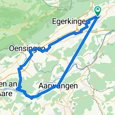
A cycling route starting in Hägendorf, Canton of Solothurn, Switzerland.
Overview
About this route
- -:--
- Duration
- 45.6 km
- Distance
- 185 m
- Ascent
- 110 m
- Descent
- ---
- Avg. speed
- ---
- Max. altitude

Part of
Bodensee Rundfahrt
7 stages
Route quality
Waytypes & surfaces along the route
Waytypes
Quiet road
18.7 km
(41 %)
Road
15.5 km
(34 %)
Surfaces
Paved
37.8 km
(83 %)
Unpaved
5 km
(11 %)
Asphalt
37.4 km
(82 %)
Gravel
5 km
(11 %)
Route highlights
Points of interest along the route
Point of interest after 45.6 km
Ziel Bodensee Rundfahrt Zu Hause
Continue with Bikemap
Use, edit, or download this cycling route
You would like to ride Letzte Etappe Bodensee Rundfahrt or customize it for your own trip? Here is what you can do with this Bikemap route:
Free features
- Save this route as favorite or in collections
- Copy & plan your own version of this route
- Sync your route with Garmin or Wahoo
Premium features
Free trial for 3 days, or one-time payment. More about Bikemap Premium.
- Navigate this route on iOS & Android
- Export a GPX / KML file of this route
- Create your custom printout (try it for free)
- Download this route for offline navigation
Discover more Premium features.
Get Bikemap PremiumFrom our community
Other popular routes starting in Hägendorf
 Moderate Route in Hägendorf
- Distance
- 39.7 km
- Ascent
- 133 m
- Descent
- 134 m
- Location
- Hägendorf, Canton of Solothurn, Switzerland
 oberer Hauenstein Baselbiet Benkerjoch
- Distance
- 104.5 km
- Ascent
- 1,376 m
- Descent
- 1,376 m
- Location
- Hägendorf, Canton of Solothurn, Switzerland
 Letzte Etappe Bodensee Rundfahrt
- Distance
- 45.6 km
- Ascent
- 185 m
- Descent
- 110 m
- Location
- Hägendorf, Canton of Solothurn, Switzerland
 Langenbruckstrasse 17, Hägendorf nach Langenbruckstrasse 10, Hägendorf
- Distance
- 24.7 km
- Ascent
- 589 m
- Descent
- 585 m
- Location
- Hägendorf, Canton of Solothurn, Switzerland
 3. Etappe: Kappel - Barbareche
- Distance
- 102.1 km
- Ascent
- 548 m
- Descent
- 349 m
- Location
- Hägendorf, Canton of Solothurn, Switzerland
 Chasseral Mt.Crosin Schelten Chilchzimmer
- Distance
- 208.9 km
- Ascent
- 2,754 m
- Descent
- 2,754 m
- Location
- Hägendorf, Canton of Solothurn, Switzerland
 Hägendorf Staffelegg Scherz Hägendorf
- Distance
- 91 km
- Ascent
- 864 m
- Descent
- 864 m
- Location
- Hägendorf, Canton of Solothurn, Switzerland
 Nellenacker 45, Hägendorf nach Bühlweg 1, Hägendorf
- Distance
- 30.6 km
- Ascent
- 217 m
- Descent
- 201 m
- Location
- Hägendorf, Canton of Solothurn, Switzerland
Open it in the app