

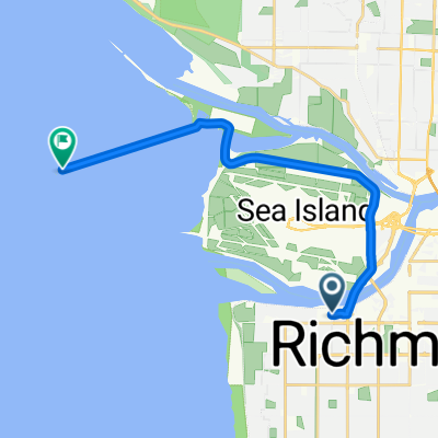
Richmond to Jericho Beach
A cycling route starting in Richmond, British Columbia, Canada.
Overview
About this route
This is a nice route from Richmond, around UBC and down to Jericho beach. There is smaller "sprint" hills on the way with a long easier grade hill as you enter UBC. Than you finish yith a nice decent down to Jericho beach (fastest I've gone is 56km down the hill, others go faster). There is washrooms at the beach. Than you go back! The last hill there at Jericho beach is a nice hill climb not super long but its fun.
- -:--
- Duration
- 23.7 km
- Distance
- 166 m
- Ascent
- 158 m
- Descent
- ---
- Avg. speed
- ---
- Max. altitude
Route quality
Waytypes & surfaces along the route
Waytypes
Road
7.4 km
(31 %)
Quiet road
3.6 km
(15 %)
Surfaces
Paved
21.4 km
(90 %)
Asphalt
20.9 km
(88 %)
Paved (undefined)
0.5 km
(2 %)
Undefined
2.4 km
(10 %)
Route highlights
Points of interest along the route
Point of interest after 19.9 km
this is the decent of a nice hill
Point of interest after 23.1 km
the ascent of the nice hill
Point of interest after 23.7 km
there are bathrooms here at the beach
Continue with Bikemap
Use, edit, or download this cycling route
You would like to ride Richmond to Jericho Beach or customize it for your own trip? Here is what you can do with this Bikemap route:
Free features
- Save this route as favorite or in collections
- Copy & plan your own version of this route
- Sync your route with Garmin or Wahoo
Premium features
Free trial for 3 days, or one-time payment. More about Bikemap Premium.
- Navigate this route on iOS & Android
- Export a GPX / KML file of this route
- Create your custom printout (try it for free)
- Download this route for offline navigation
Discover more Premium features.
Get Bikemap PremiumFrom our community
Other popular routes starting in Richmond
 Richmond 50km
- Distance
- 46.9 km
- Ascent
- 13 m
- Descent
- 13 m
- Location
- Richmond, British Columbia, Canada
 Finlayson Drive to East Kent Avenue South
- Distance
- 60.3 km
- Ascent
- 108 m
- Descent
- 109 m
- Location
- Richmond, British Columbia, Canada
 Richmond River Rd to Iona Island
- Distance
- 14 km
- Ascent
- 12 m
- Descent
- 14 m
- Location
- Richmond, British Columbia, Canada
 Ride for Refuge - 10 km
- Distance
- 9.9 km
- Ascent
- 4 m
- Descent
- 3 m
- Location
- Richmond, British Columbia, Canada
 Iona Loop
- Distance
- 31.4 km
- Ascent
- 9 m
- Descent
- 9 m
- Location
- Richmond, British Columbia, Canada
 Richmond to Jericho Beach
- Distance
- 23.7 km
- Ascent
- 166 m
- Descent
- 158 m
- Location
- Richmond, British Columbia, Canada
 Richmond Dykes
- Distance
- 18 km
- Ascent
- 4 m
- Descent
- 5 m
- Location
- Richmond, British Columbia, Canada
 Iona Richmond Loop (80km)
- Distance
- 79.9 km
- Ascent
- 21 m
- Descent
- 24 m
- Location
- Richmond, British Columbia, Canada
Open it in the app