

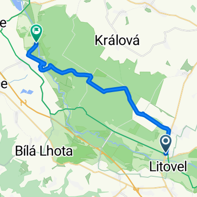
Litovel - FREE JÍZDA
A cycling route starting in Litovel, Olomoucký kraj, Czechia.
Overview
About this route
- -:--
- Duration
- 28.5 km
- Distance
- 76 m
- Ascent
- 78 m
- Descent
- ---
- Avg. speed
- ---
- Max. altitude

Route quality
Waytypes & surfaces along the route
Waytypes
Track
20.8 km
(73 %)
Road
2.6 km
(9 %)
Surfaces
Paved
10.6 km
(37 %)
Unpaved
10.3 km
(36 %)
Asphalt
7.7 km
(27 %)
Gravel
4.3 km
(15 %)
Continue with Bikemap
Use, edit, or download this cycling route
You would like to ride Litovel - FREE JÍZDA or customize it for your own trip? Here is what you can do with this Bikemap route:
Free features
- Save this route as favorite or in collections
- Copy & plan your own version of this route
- Sync your route with Garmin or Wahoo
Premium features
Free trial for 3 days, or one-time payment. More about Bikemap Premium.
- Navigate this route on iOS & Android
- Export a GPX / KML file of this route
- Create your custom printout (try it for free)
- Download this route for offline navigation
Discover more Premium features.
Get Bikemap PremiumFrom our community
Other popular routes starting in Litovel
 Litovel - FREE JÍZDA
- Distance
- 28.5 km
- Ascent
- 76 m
- Descent
- 78 m
- Location
- Litovel, Olomoucký kraj, Czechia
 Litovel - Praděd
- Distance
- 69.6 km
- Ascent
- 1,426 m
- Descent
- 170 m
- Location
- Litovel, Olomoucký kraj, Czechia
 Triatlon Sobáčov
- Distance
- 20.7 km
- Ascent
- 277 m
- Descent
- 276 m
- Location
- Litovel, Olomoucký kraj, Czechia
 Litovel_Bouzov_1.0
- Distance
- 43.3 km
- Ascent
- 334 m
- Descent
- 335 m
- Location
- Litovel, Olomoucký kraj, Czechia
 Gemerská do Silnice Bez Názvu
- Distance
- 14.5 km
- Ascent
- 95 m
- Descent
- 80 m
- Location
- Litovel, Olomoucký kraj, Czechia
 Litovel-Bouzov_5.0
- Distance
- 42.7 km
- Ascent
- 361 m
- Descent
- 360 m
- Location
- Litovel, Olomoucký kraj, Czechia
 Litovel - Dlouhé stráně horní nádrž
- Distance
- 66.5 km
- Ascent
- 1,356 m
- Descent
- 250 m
- Location
- Litovel, Olomoucký kraj, Czechia
 Vl.22.7.So Litovel-Sumperk-Hanusovice-Kraliky-Pastviny
- Distance
- 96.7 km
- Ascent
- 1,266 m
- Descent
- 1,011 m
- Location
- Litovel, Olomoucký kraj, Czechia
Open it in the app