

Schächental Bike
A cycling route starting in Muotathal, Canton of Schwyz, Switzerland.
Overview
About this route
Starting point: Altdorf, Bahnhof
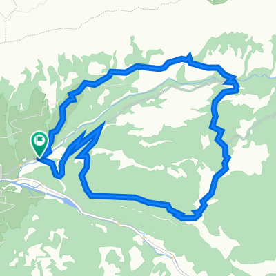
The tour along the Höhenweg Schächental is the classic among bike paths. The dreamy panoramic ride promises optimal infrastructure and challenging climbs and descents in a charming landscape. Passing by Bürglen, the hometown of William Tell, you will continue with a gentle ascent on the Klausenpassstraße through the elongated Schächental. The impressively carved Klausenstraße along the «Lini» presents itself majestically. At over 400 meters deep, one can see the hamlet of Aesch with its waterfall spraying over 90 meters high. On the natural road over the Schächentaler Höhenweg, you will be inspired by an impressive mountain panorama and beautiful alpine settlements. Don't forget to take a piece of Urner alpine cheese from one of the many alpine huts along the way. The next imposing climb and descent with a grand view over the Schächen and Reuss valleys will delight you. Sharp, but short climbs provide variety to your heart rate on this section – and the mountain guesthouses along the route offer a wide range of options for resting. After the idyllic valley basin near Steinselez, a final ascent to Fleschseeli awaits you before you tackle the last treat of this attractive tour, descending through Eggberge and the Altdorfer Bannwald.
The route is continuously signposted with number 416.
- -:--
- Duration
- 55.9 km
- Distance
- 1,916 m
- Ascent
- 1,739 m
- Descent
- ---
- Avg. speed
- ---
- Max. altitude

Route quality
Waytypes & surfaces along the route
Waytypes
Track
16.2 km
(29 %)
Quiet road
10.6 km
(19 %)
Surfaces
Paved
31.8 km
(57 %)
Unpaved
18.4 km
(33 %)
Asphalt
31.3 km
(56 %)
Gravel
16.8 km
(30 %)
Continue with Bikemap
Use, edit, or download this cycling route
You would like to ride Schächental Bike or customize it for your own trip? Here is what you can do with this Bikemap route:
Free features
- Save this route as favorite or in collections
- Copy & plan your own version of this route
- Sync your route with Garmin or Wahoo
Premium features
Free trial for 3 days, or one-time payment. More about Bikemap Premium.
- Navigate this route on iOS & Android
- Export a GPX / KML file of this route
- Create your custom printout (try it for free)
- Download this route for offline navigation
Discover more Premium features.
Get Bikemap PremiumFrom our community
Other popular routes starting in Muotathal
 W/Muotathal gross
- Distance
- 17.4 km
- Ascent
- 843 m
- Descent
- 791 m
- Location
- Muotathal, Canton of Schwyz, Switzerland
 Einsiedeln-Ibergeregg-Pragel-Schwialppass-Sattelegg
- Distance
- 74.4 km
- Ascent
- 2,266 m
- Descent
- 2,264 m
- Location
- Muotathal, Canton of Schwyz, Switzerland
 Muotathal - Uznach - Küsnacht
- Distance
- 97.1 km
- Ascent
- 1,430 m
- Descent
- 1,604 m
- Location
- Muotathal, Canton of Schwyz, Switzerland
 WanderWunder Schwyz: Rundwanderung Muotathal mit Plattenweg
- Distance
- 13.3 km
- Ascent
- 1,033 m
- Descent
- 1,031 m
- Location
- Muotathal, Canton of Schwyz, Switzerland
 Illgau - Aufiberg
- Distance
- 14.8 km
- Ascent
- 630 m
- Descent
- 630 m
- Location
- Muotathal, Canton of Schwyz, Switzerland
 Schächental Bike
- Distance
- 55.9 km
- Ascent
- 1,916 m
- Descent
- 1,739 m
- Location
- Muotathal, Canton of Schwyz, Switzerland
 Stoos
Stoos- Distance
- 12.4 km
- Ascent
- 1,346 m
- Descent
- 19 m
- Location
- Muotathal, Canton of Schwyz, Switzerland
 Route im Schneckentempo in Glarus
- Distance
- 18.9 km
- Ascent
- 69 m
- Descent
- 1,109 m
- Location
- Muotathal, Canton of Schwyz, Switzerland
Open it in the app