

SGA-Radtour 2019 Vorschlag 1 Teil 1 Darmstadt-Mittelmeer-Atlantik
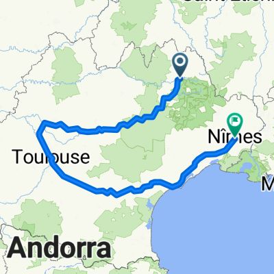
Sainte-Enimie - Valras-Plage
A cycling route starting in Mende, Occitanie, France.
Overview
About this route
SGA - Cycling Tour 2019
8th stage on 14.06.2019
- -:--
- Duration
- 200.3 km
- Distance
- 1,004 m
- Ascent
- 1,485 m
- Descent
- ---
- Avg. speed
- ---
- Max. altitude

Part of
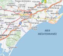
Route photos


Route quality
Waytypes & surfaces along the route
Waytypes
Road
40.1 km
(20 %)
Quiet road
14 km
(7 %)
Surfaces
Paved
106.1 km
(53 %)
Unpaved
2 km
(1 %)
Asphalt
106.1 km
(53 %)
Gravel
2 km
(1 %)
Undefined
92.1 km
(46 %)
Continue with Bikemap
Use, edit, or download this cycling route
You would like to ride Sainte-Enimie - Valras-Plage or customize it for your own trip? Here is what you can do with this Bikemap route:
Free features
- Save this route as favorite or in collections
- Copy & plan your own version of this route
- Split it into stages to create a multi-day tour
- Sync your route with Garmin or Wahoo
Premium features
Free trial for 3 days, or one-time payment. More about Bikemap Premium.
- Navigate this route on iOS & Android
- Export a GPX / KML file of this route
- Create your custom printout (try it for free)
- Download this route for offline navigation
Discover more Premium features.
Get Bikemap PremiumFrom our community
Other popular routes starting in Mende
 Patchwork au nord du Mont Lozère
- Distance
- 64.3 km
- Ascent
- 1,407 m
- Descent
- 1,407 m
- Location
- Mende, Occitanie, France
 2016 Ride Day 111 - Mende to Banassac
- Distance
- 51.7 km
- Ascent
- 792 m
- Descent
- 978 m
- Location
- Mende, Occitanie, France
 TMC5_Bagnols les Bains - Florac 3 rivières
- Distance
- 66 km
- Ascent
- 2,225 m
- Descent
- 2,607 m
- Location
- Mende, Occitanie, France
 2016 Ride Day 137 - Mende to Le Malzieu-Ville
- Distance
- 49.5 km
- Ascent
- 917 m
- Descent
- 759 m
- Location
- Mende, Occitanie, France
 Margeride/gorges du tarn/Mont Lozere
- Distance
- 369.5 km
- Ascent
- 3,488 m
- Descent
- 3,469 m
- Location
- Mende, Occitanie, France
 Ferme Amarger,Charpal,crêtes du mont Lozere,retour
- Distance
- 110.9 km
- Ascent
- 1,447 m
- Descent
- 1,457 m
- Location
- Mende, Occitanie, France
 05-X. Mende - Avignon (175 Km)
- Distance
- 175 km
- Ascent
- 2,253 m
- Descent
- 2,971 m
- Location
- Mende, Occitanie, France
 Okzitanien_Variante C
- Distance
- 674.3 km
- Ascent
- 640 m
- Descent
- 1,304 m
- Location
- Mende, Occitanie, France
Open it in the app