
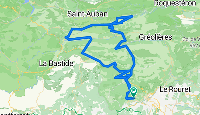
Roundtrip from Cabris to La Mas
A cycling route starting in Cabris, Provence-Alpes-Côte d'Azur Region, France.
Overview
About this route
- -:--
- Duration
- 118.9 km
- Distance
- 1,756 m
- Ascent
- 1,769 m
- Descent
- ---
- Avg. speed
- ---
- Max. altitude
Route quality
Waytypes & surfaces along the route
Waytypes
Busy road
61.4 km
(52 %)
Road
41.5 km
(35 %)
Surfaces
Paved
25.3 km
(21 %)
Unpaved
0 km
(<1 %)
Asphalt
25.3 km
(21 %)
Unpaved (undefined)
0 km
(<1 %)
Undefined
93.5 km
(79 %)
Continue with Bikemap
Use, edit, or download this cycling route
You would like to ride Roundtrip from Cabris to La Mas or customize it for your own trip? Here is what you can do with this Bikemap route:
Free features
- Save this route as favorite or in collections
- Copy & plan your own version of this route
- Split it into stages to create a multi-day tour
- Sync your route with Garmin or Wahoo
Premium features
Free trial for 3 days, or one-time payment. More about Bikemap Premium.
- Navigate this route on iOS & Android
- Export a GPX / KML file of this route
- Create your custom printout (try it for free)
- Download this route for offline navigation
Discover more Premium features.
Get Bikemap PremiumFrom our community
Other popular routes starting in Cabris
 De Boulevard Jean Marais 1325, Cabris à Boulevard Jean Marais 1375, Cabris
- Distance
- 27.6 km
- Ascent
- 589 m
- Descent
- 688 m
- Location
- Cabris, Provence-Alpes-Côte d'Azur Region, France
 From Cabris around the canyon
- Distance
- 209.9 km
- Ascent
- 2,868 m
- Descent
- 2,868 m
- Location
- Cabris, Provence-Alpes-Côte d'Azur Region, France
 De Boulevard Jean Marais 1375, Cabris à Boulevard Jean Marais 1375, Cabris
- Distance
- 23.2 km
- Ascent
- 194 m
- Descent
- 236 m
- Location
- Cabris, Provence-Alpes-Côte d'Azur Region, France
 From Cabris to Saint Raphael and back via Mandelieu
- Distance
- 107.6 km
- Ascent
- 1,412 m
- Descent
- 1,412 m
- Location
- Cabris, Provence-Alpes-Côte d'Azur Region, France
 Cabris-Mons-Escragnolies-Cabris
- Distance
- 73 km
- Ascent
- 1,246 m
- Descent
- 1,228 m
- Location
- Cabris, Provence-Alpes-Côte d'Azur Region, France
 De Boulevard Jean Marais 1375, Cabris à Boulevard Jean Marais 1375, Cabris
- Distance
- 31.3 km
- Ascent
- 489 m
- Descent
- 478 m
- Location
- Cabris, Provence-Alpes-Côte d'Azur Region, France
 Roundtrip from Cabris to La Mas
- Distance
- 118.9 km
- Ascent
- 1,756 m
- Descent
- 1,769 m
- Location
- Cabris, Provence-Alpes-Côte d'Azur Region, France
 Cabris-Mons
- Distance
- 76.8 km
- Ascent
- 1,368 m
- Descent
- 1,348 m
- Location
- Cabris, Provence-Alpes-Côte d'Azur Region, France
Open it in the app