

Andalusien 5
A cycling route starting in La Herradura, Andalusia, Spain.
Overview
About this route
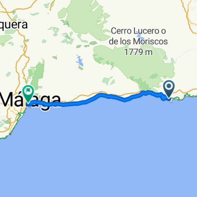
von Almunecar an der Küste antlang nach Malaga - friedliche Schlussettape im strömenden Regen :-(
- -:--
- Duration
- 75.2 km
- Distance
- 378 m
- Ascent
- 372 m
- Descent
- ---
- Avg. speed
- ---
- Max. altitude

Continue with Bikemap
Use, edit, or download this cycling route
You would like to ride Andalusien 5 or customize it for your own trip? Here is what you can do with this Bikemap route:
Free features
- Save this route as favorite or in collections
- Copy & plan your own version of this route
- Sync your route with Garmin or Wahoo
Premium features
Free trial for 3 days, or one-time payment. More about Bikemap Premium.
- Navigate this route on iOS & Android
- Export a GPX / KML file of this route
- Create your custom printout (try it for free)
- Download this route for offline navigation
Discover more Premium features.
Get Bikemap PremiumFrom our community
Other popular routes starting in La Herradura
 Park bag bed La herradura
- Distance
- 56.3 km
- Ascent
- 2,033 m
- Descent
- 2,033 m
- Location
- La Herradura, Andalusia, Spain
 Andalusien 5
- Distance
- 75.2 km
- Ascent
- 378 m
- Descent
- 372 m
- Location
- La Herradura, Andalusia, Spain
 2018/5 Motril to Aguilas
- Distance
- 321.9 km
- Ascent
- 1,135 m
- Descent
- 1,115 m
- Location
- La Herradura, Andalusia, Spain
 La Herradura - Otívar
- Distance
- 19.6 km
- Ascent
- 566 m
- Descent
- 414 m
- Location
- La Herradura, Andalusia, Spain
 Lunch Ride
- Distance
- 38.8 km
- Ascent
- 1,235 m
- Descent
- 1,212 m
- Location
- La Herradura, Andalusia, Spain
 Meine Königsetappe Andalucia 2013
- Distance
- 177.2 km
- Ascent
- 4,373 m
- Descent
- 4,374 m
- Location
- La Herradura, Andalusia, Spain
 De Diseminado Río Jate Pol 21, 105B, Almuñécar a Plaza Rincón de las Galeras, Almuñécar
- Distance
- 10.1 km
- Ascent
- 141 m
- Descent
- 247 m
- Location
- La Herradura, Andalusia, Spain
 Cañuelo, alto de los Castillejos,El Rescate,El cerval,La Herradura
- Distance
- 37.4 km
- Ascent
- 1,198 m
- Descent
- 1,198 m
- Location
- La Herradura, Andalusia, Spain
Open it in the app