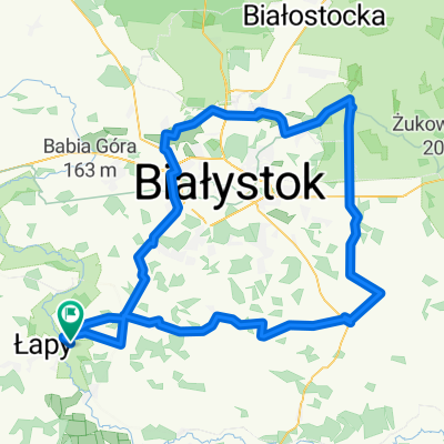
Waniewo #1
A cycling route starting in Łapy, Podlasie Voivodship, Poland.
Overview
About this route
- 2 h 52 min
- Duration
- 42.7 km
- Distance
- 1,129 m
- Ascent
- 1,133 m
- Descent
- 14.9 km/h
- Avg. speed
- ---
- Avg. speed
Route quality
Waytypes & surfaces along the route
Waytypes
Road
28.5 km
(67 %)
Busy road
5.2 km
(12 %)
Surfaces
Paved
38.6 km
(90 %)
Unpaved
1.6 km
(4 %)
Asphalt
36 km
(84 %)
Paving stones
1.4 km
(3 %)
Continue with Bikemap
Use, edit, or download this cycling route
You would like to ride Waniewo #1 or customize it for your own trip? Here is what you can do with this Bikemap route:
Free features
- Save this route as favorite or in collections
- Copy & plan your own version of this route
- Sync your route with Garmin or Wahoo
Premium features
Free trial for 3 days, or one-time payment. More about Bikemap Premium.
- Navigate this route on iOS & Android
- Export a GPX / KML file of this route
- Create your custom printout (try it for free)
- Download this route for offline navigation
Discover more Premium features.
Get Bikemap PremiumFrom our community
Other popular routes starting in Łapy
- ATRAKCJE PODLASIE
- Distance
- 1.1 km
- Ascent
- 8 m
- Descent
- 0 m
- Location
- Łapy, Podlasie Voivodship, Poland
- podlasie 2020
- Distance
- 191.9 km
- Ascent
- 225 m
- Descent
- 188 m
- Location
- Łapy, Podlasie Voivodship, Poland
- etp1 323
- Distance
- 323.1 km
- Ascent
- 411 m
- Descent
- 408 m
- Location
- Łapy, Podlasie Voivodship, Poland
- nad narwią, bez słońca
- Distance
- 25.5 km
- Ascent
- 64 m
- Descent
- 63 m
- Location
- Łapy, Podlasie Voivodship, Poland
- 1. Waniewo - Śliwno
- Distance
- 18.6 km
- Ascent
- 91 m
- Descent
- 56 m
- Location
- Łapy, Podlasie Voivodship, Poland
- Waniewo #1
- Distance
- 42.7 km
- Ascent
- 1,129 m
- Descent
- 1,133 m
- Location
- Łapy, Podlasie Voivodship, Poland
- Łapy-Uhowo-Borowskie-Turośń Kość.-Pomigacze
- Distance
- 44.2 km
- Ascent
- 86 m
- Descent
- 86 m
- Location
- Łapy, Podlasie Voivodship, Poland
- Waniewo 69, Sokoły do Kolejowa 18B, Sokoły
- Distance
- 12.9 km
- Ascent
- 683 m
- Descent
- 657 m
- Location
- Łapy, Podlasie Voivodship, Poland
Open it in the app