

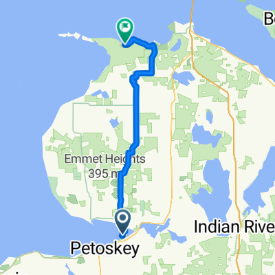
Petosky state park to Leggs Inn
A cycling route starting in Petoskey, Michigan, United States.
Overview
About this route
52 miles
- -:--
- Duration
- 42.3 km
- Distance
- 307 m
- Ascent
- 295 m
- Descent
- ---
- Avg. speed
- ---
- Max. altitude

Route quality
Waytypes & surfaces along the route
Waytypes
Cycleway
5.1 km
(12 %)
Road
3 km
(7 %)
Surfaces
Paved
37.2 km
(88 %)
Asphalt
31.7 km
(75 %)
Paved (undefined)
5.5 km
(13 %)
Undefined
5.1 km
(12 %)
Continue with Bikemap
Use, edit, or download this cycling route
You would like to ride Petosky state park to Leggs Inn or customize it for your own trip? Here is what you can do with this Bikemap route:
Free features
- Save this route as favorite or in collections
- Copy & plan your own version of this route
- Sync your route with Garmin or Wahoo
Premium features
Free trial for 3 days, or one-time payment. More about Bikemap Premium.
- Navigate this route on iOS & Android
- Export a GPX / KML file of this route
- Create your custom printout (try it for free)
- Download this route for offline navigation
Discover more Premium features.
Get Bikemap PremiumFrom our community
Other popular routes starting in Petoskey
 1890 US-131, Petoskey to Lake Shore Dr, Charlevoix
- Distance
- 67.2 km
- Ascent
- 504 m
- Descent
- 603 m
- Location
- Petoskey, Michigan, United States
 Petoskey SP to Wilderness SP
- Distance
- 53 km
- Ascent
- 225 m
- Descent
- 236 m
- Location
- Petoskey, Michigan, United States
 Petosky state park to Leggs Inn
- Distance
- 42.3 km
- Ascent
- 307 m
- Descent
- 295 m
- Location
- Petoskey, Michigan, United States
 Huron- Day 2- Petoskey to Mackinac Bridge
- Distance
- 86.9 km
- Ascent
- 229 m
- Descent
- 230 m
- Location
- Petoskey, Michigan, United States
 Petoskey to 284 Harbor Dr E, Harbor Springs
- Distance
- 9.2 km
- Ascent
- 46 m
- Descent
- 61 m
- Location
- Petoskey, Michigan, United States
 N Western Michigan Trail, Petoskey to 7525 US-31, Alanson
- Distance
- 18.9 km
- Ascent
- 28 m
- Descent
- 28 m
- Location
- Petoskey, Michigan, United States
 601–799 W Lake St, Petoskey to 601–799 W Lake St, Petoskey
- Distance
- 314.7 km
- Ascent
- 274 m
- Descent
- 273 m
- Location
- Petoskey, Michigan, United States
 1890 US-131, Petoskey to 702 S Nicolet St, Mackinaw City
- Distance
- 62.7 km
- Ascent
- 140 m
- Descent
- 236 m
- Location
- Petoskey, Michigan, United States
Open it in the app