Sonnleiten - Fernreith
A cycling route starting in Buchkirchen, Upper Austria, Austria.
Overview
About this route
- -:--
- Duration
- 17.2 km
- Distance
- 129 m
- Ascent
- 128 m
- Descent
- ---
- Avg. speed
- 377 m
- Max. altitude
Route quality
Waytypes & surfaces along the route
Waytypes
Quiet road
10.1 km
(59 %)
Road
5.1 km
(30 %)
Surfaces
Paved
11.6 km
(67 %)
Asphalt
11.6 km
(67 %)
Undefined
5.6 km
(33 %)
Continue with Bikemap
Use, edit, or download this cycling route
You would like to ride Sonnleiten - Fernreith or customize it for your own trip? Here is what you can do with this Bikemap route:
Free features
- Save this route as favorite or in collections
- Copy & plan your own version of this route
- Sync your route with Garmin or Wahoo
Premium features
Free trial for 3 days, or one-time payment. More about Bikemap Premium.
- Navigate this route on iOS & Android
- Export a GPX / KML file of this route
- Create your custom printout (try it for free)
- Download this route for offline navigation
Discover more Premium features.
Get Bikemap PremiumFrom our community
Other popular routes starting in Buchkirchen
- Sonnleiten - Fernreith
- Distance
- 17.2 km
- Ascent
- 129 m
- Descent
- 128 m
- Location
- Buchkirchen, Upper Austria, Austria
- Scharten
- Distance
- 17.9 km
- Ascent
- 466 m
- Descent
- 424 m
- Location
- Buchkirchen, Upper Austria, Austria
- Hoch und Runter am Sonntag Vormittag
- Distance
- 17.2 km
- Ascent
- 175 m
- Descent
- 177 m
- Location
- Buchkirchen, Upper Austria, Austria
- Marchtrenker Straße 26, Oberhocherenz nach Oberhocherenz 24
- Distance
- 32.7 km
- Ascent
- 269 m
- Descent
- 262 m
- Location
- Buchkirchen, Upper Austria, Austria
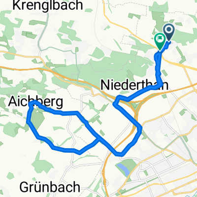
- Flache Traunroute bis nach Traun
- Distance
- 52.3 km
- Ascent
- 146 m
- Descent
- 146 m
- Location
- Buchkirchen, Upper Austria, Austria
- Grieskirchen auf a EIS
- Distance
- 44.6 km
- Ascent
- 287 m
- Descent
- 284 m
- Location
- Buchkirchen, Upper Austria, Austria
- Motocross-Strecke Puchberg (Militärgelände)
- Distance
- 4.1 km
- Ascent
- 76 m
- Descent
- 74 m
- Location
- Buchkirchen, Upper Austria, Austria
- Katzbach-Scharten-Eferding-Stroheim
- Distance
- 54.2 km
- Ascent
- 677 m
- Descent
- 701 m
- Location
- Buchkirchen, Upper Austria, Austria
Open it in the app