

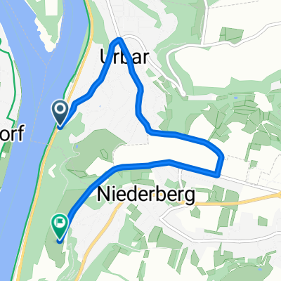
Tour kannenbäckerland
A cycling route starting in Urbar, Rhineland-Palatinate, Germany.
Overview
About this route
- -:--
- Duration
- 46.6 km
- Distance
- 492 m
- Ascent
- 518 m
- Descent
- ---
- Avg. speed
- ---
- Max. altitude

Route quality
Waytypes & surfaces along the route
Waytypes
Track
16.8 km
(36 %)
Path
9.8 km
(21 %)
Surfaces
Paved
24.7 km
(53 %)
Unpaved
17.2 km
(37 %)
Asphalt
21.4 km
(46 %)
Unpaved (undefined)
6.5 km
(14 %)
Continue with Bikemap
Use, edit, or download this cycling route
You would like to ride Tour kannenbäckerland or customize it for your own trip? Here is what you can do with this Bikemap route:
Free features
- Save this route as favorite or in collections
- Copy & plan your own version of this route
- Sync your route with Garmin or Wahoo
Premium features
Free trial for 3 days, or one-time payment. More about Bikemap Premium.
- Navigate this route on iOS & Android
- Export a GPX / KML file of this route
- Create your custom printout (try it for free)
- Download this route for offline navigation
Discover more Premium features.
Get Bikemap PremiumFrom our community
Other popular routes starting in Urbar
 Über den Köppel
- Distance
- 61.3 km
- Ascent
- 870 m
- Descent
- 977 m
- Location
- Urbar, Rhineland-Palatinate, Germany
 Tour kannenbäckerland
- Distance
- 46.6 km
- Ascent
- 492 m
- Descent
- 518 m
- Location
- Urbar, Rhineland-Palatinate, Germany
 A-BE40
- Distance
- 39.8 km
- Ascent
- 818 m
- Descent
- 820 m
- Location
- Urbar, Rhineland-Palatinate, Germany
 7-Brücken-Runde Teil 2 19 km
- Distance
- 17.1 km
- Ascent
- 71 m
- Descent
- 184 m
- Location
- Urbar, Rhineland-Palatinate, Germany
 Koblenz-Köln
- Distance
- 98.8 km
- Ascent
- 68 m
- Descent
- 75 m
- Location
- Urbar, Rhineland-Palatinate, Germany
 KO-Ehrenbreitstein
- Distance
- 4.5 km
- Ascent
- 115 m
- Descent
- 11 m
- Location
- Urbar, Rhineland-Palatinate, Germany
 Skattour mosel rhein
- Distance
- 141.2 km
- Ascent
- 783 m
- Descent
- 767 m
- Location
- Urbar, Rhineland-Palatinate, Germany
 Festung Immendorf, Golfplatz, TÜP, Festung
- Distance
- 30.5 km
- Ascent
- 454 m
- Descent
- 452 m
- Location
- Urbar, Rhineland-Palatinate, Germany
Open it in the app