
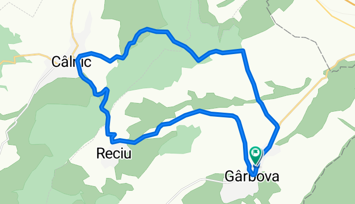
Garbova-Calnic-Reciu-Garbova
A cycling route starting in Gârbova, Alba County, Romania.
Overview
About this route
- 1 h 37 min
- Duration
- 18.2 km
- Distance
- 291 m
- Ascent
- 314 m
- Descent
- 11.3 km/h
- Avg. speed
- ---
- Max. altitude

Route photos


Continue with Bikemap
Use, edit, or download this cycling route
You would like to ride Garbova-Calnic-Reciu-Garbova or customize it for your own trip? Here is what you can do with this Bikemap route:
Free features
- Save this route as favorite or in collections
- Copy & plan your own version of this route
- Sync your route with Garmin or Wahoo
Premium features
Free trial for 3 days, or one-time payment. More about Bikemap Premium.
- Navigate this route on iOS & Android
- Export a GPX / KML file of this route
- Create your custom printout (try it for free)
- Download this route for offline navigation
Discover more Premium features.
Get Bikemap PremiumFrom our community
Other popular routes starting in Gârbova
 2015.08.18.
- Distance
- 81.5 km
- Ascent
- 1,273 m
- Descent
- 1,144 m
- Location
- Gârbova, Alba County, Romania
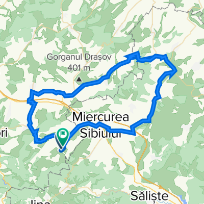
 Garbova-Sibiel-Calnic
- Distance
- 100.8 km
- Ascent
- 1,660 m
- Descent
- 1,646 m
- Location
- Gârbova, Alba County, Romania
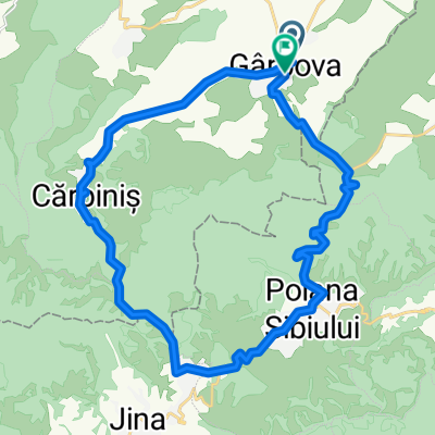 Garbova-Jina-Garbova
- Distance
- 26.4 km
- Ascent
- 620 m
- Descent
- 614 m
- Location
- Gârbova, Alba County, Romania
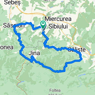 Garbova-Saliste-Calnic
- Distance
- 101.3 km
- Ascent
- 1,697 m
- Descent
- 1,679 m
- Location
- Gârbova, Alba County, Romania
 Garbova-Calnic-Reciu-Garbova
- Distance
- 18.5 km
- Ascent
- 359 m
- Descent
- 333 m
- Location
- Gârbova, Alba County, Romania
 Garbova (Sibiu)
- Distance
- 115.6 km
- Ascent
- 1,660 m
- Descent
- 1,660 m
- Location
- Gârbova, Alba County, Romania
 Garbova-Calnic-Reciu-Garbova
- Distance
- 18.2 km
- Ascent
- 291 m
- Descent
- 314 m
- Location
- Gârbova, Alba County, Romania
 DC72A 475, Gârbova to Gârbova
- Distance
- 70.4 km
- Ascent
- 649 m
- Descent
- 659 m
- Location
- Gârbova, Alba County, Romania
Open it in the app