

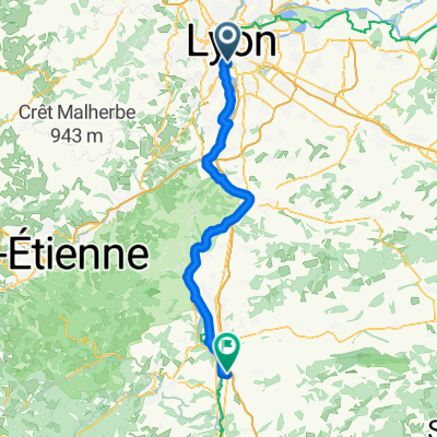
F 610: Lyon - Vienne - Lyon
A cycling route starting in La Mulatière, Auvergne-Rhône-Alpes, France.
Overview
About this route
- -:--
- Duration
- 70.8 km
- Distance
- 415 m
- Ascent
- 413 m
- Descent
- ---
- Avg. speed
- ---
- Max. altitude
Route quality
Waytypes & surfaces along the route
Waytypes
Quiet road
27.6 km
(39 %)
Road
13.5 km
(19 %)
Surfaces
Paved
39.6 km
(56 %)
Unpaved
5.7 km
(8 %)
Asphalt
37.5 km
(53 %)
Loose gravel
3.5 km
(5 %)
Continue with Bikemap
Use, edit, or download this cycling route
You would like to ride F 610: Lyon - Vienne - Lyon or customize it for your own trip? Here is what you can do with this Bikemap route:
Free features
- Save this route as favorite or in collections
- Copy & plan your own version of this route
- Sync your route with Garmin or Wahoo
Premium features
Free trial for 3 days, or one-time payment. More about Bikemap Premium.
- Navigate this route on iOS & Android
- Export a GPX / KML file of this route
- Create your custom printout (try it for free)
- Download this route for offline navigation
Discover more Premium features.
Get Bikemap PremiumFrom our community
Other popular routes starting in La Mulatière
 Activity - La Voie Bleue - Moselle-Saône à vélo
- Distance
- 658.2 km
- Ascent
- 2,447 m
- Descent
- 2,454 m
- Location
- La Mulatière, Auvergne-Rhône-Alpes, France
 Lyon - Saint Rambert-d'Albon
- Distance
- 73 km
- Ascent
- 382 m
- Descent
- 394 m
- Location
- La Mulatière, Auvergne-Rhône-Alpes, France
 Les 7 Cols des Monts du Lyonnais
- Distance
- 205.5 km
- Ascent
- 2,804 m
- Descent
- 2,711 m
- Location
- La Mulatière, Auvergne-Rhône-Alpes, France
 september day1
- Distance
- 68.6 km
- Ascent
- 28 m
- Descent
- 59 m
- Location
- La Mulatière, Auvergne-Rhône-Alpes, France
 F 610: Lyon - Vienne - Lyon
- Distance
- 70.8 km
- Ascent
- 415 m
- Descent
- 413 m
- Location
- La Mulatière, Auvergne-Rhône-Alpes, France
 De Quai Rambaud 52, Lyon à Musée des Confluences, Lyon
- Distance
- 73.8 km
- Ascent
- 1,427 m
- Descent
- 1,423 m
- Location
- La Mulatière, Auvergne-Rhône-Alpes, France
 Testing Testing
- Distance
- 14.5 km
- Ascent
- 307 m
- Descent
- 98 m
- Location
- La Mulatière, Auvergne-Rhône-Alpes, France
 Itinéraire facile en Lyon
- Distance
- 29.6 km
- Ascent
- 53 m
- Descent
- 54 m
- Location
- La Mulatière, Auvergne-Rhône-Alpes, France
Open it in the app