

Cantavieja_1er-A
A cycling route starting in Cantavieja, Aragon, Spain.
Overview
About this route
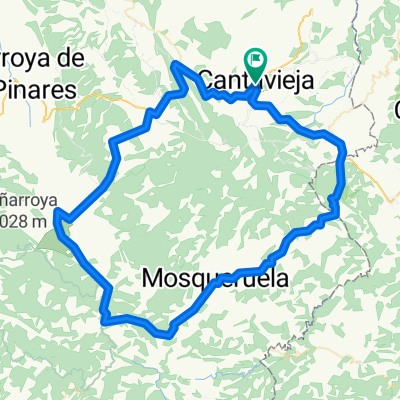
Cantavieja-Cañada de Benatanduz-Villarluengo (Las Fábricas-op. San Cristobal)-Tronchón-Miranbel-Cantavieja
- -:--
- Duration
- 73.5 km
- Distance
- 1,286 m
- Ascent
- 1,289 m
- Descent
- ---
- Avg. speed
- ---
- Max. altitude

Route quality
Waytypes & surfaces along the route
Waytypes
Road
20.6 km
(28 %)
Quiet road
7.4 km
(10 %)
Surfaces
Paved
7.4 km
(10 %)
Unpaved
3.7 km
(5 %)
Asphalt
7.4 km
(10 %)
Unpaved (undefined)
3.7 km
(5 %)
Undefined
62.5 km
(85 %)
Continue with Bikemap
Use, edit, or download this cycling route
You would like to ride Cantavieja_1er-A or customize it for your own trip? Here is what you can do with this Bikemap route:
Free features
- Save this route as favorite or in collections
- Copy & plan your own version of this route
- Sync your route with Garmin or Wahoo
Premium features
Free trial for 3 days, or one-time payment. More about Bikemap Premium.
- Navigate this route on iOS & Android
- Export a GPX / KML file of this route
- Create your custom printout (try it for free)
- Download this route for offline navigation
Discover more Premium features.
Get Bikemap PremiumFrom our community
Other popular routes starting in Cantavieja
 Cantavieja_1er_B
- Distance
- 80.7 km
- Ascent
- 1,275 m
- Descent
- 1,303 m
- Location
- Cantavieja, Aragon, Spain
 Cantavieja - Aliaga
- Distance
- 81.4 km
- Ascent
- 1,992 m
- Descent
- 2,182 m
- Location
- Cantavieja, Aragon, Spain
 Cantavieja_ 2on-Op_B
- Distance
- 118.7 km
- Ascent
- 1,748 m
- Descent
- 1,796 m
- Location
- Cantavieja, Aragon, Spain
 Cantavieja-Miranbel-Olocau-Tronchon-Cantavieja
- Distance
- 75.3 km
- Ascent
- 1,269 m
- Descent
- 1,269 m
- Location
- Cantavieja, Aragon, Spain
 Puerto cuarto pelado desde Cantavieja ida y vuelta
- Distance
- 42.5 km
- Ascent
- 715 m
- Descent
- 1,103 m
- Location
- Cantavieja, Aragon, Spain
 cantavieja (9) - teruel (10) -via verde
- Distance
- 85.4 km
- Ascent
- 1,388 m
- Descent
- 1,741 m
- Location
- Cantavieja, Aragon, Spain
 Cantavieja_1er-A
- Distance
- 73.5 km
- Ascent
- 1,286 m
- Descent
- 1,289 m
- Location
- Cantavieja, Aragon, Spain
 Cantavieja-Fortanete-Valdelinares-Linares-Mosqueruela-Iglesuela-Cantavieja
- Distance
- 97.5 km
- Ascent
- 1,520 m
- Descent
- 1,525 m
- Location
- Cantavieja, Aragon, Spain
Open it in the app