

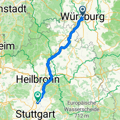
Rennrad: Würzburg - Fulda
A cycling route starting in Würzburg, Bavaria, Germany.
Overview
About this route
- -:--
- Duration
- 122.4 km
- Distance
- 1,049 m
- Ascent
- 970 m
- Descent
- ---
- Avg. speed
- ---
- Max. altitude
Route quality
Waytypes & surfaces along the route
Waytypes
Quiet road
14.7 km
(12 %)
Path
8.6 km
(7 %)
Surfaces
Paved
95.5 km
(78 %)
Unpaved
1.2 km
(1 %)
Asphalt
94.3 km
(77 %)
Paved (undefined)
1.2 km
(1 %)
Continue with Bikemap
Use, edit, or download this cycling route
You would like to ride Rennrad: Würzburg - Fulda or customize it for your own trip? Here is what you can do with this Bikemap route:
Free features
- Save this route as favorite or in collections
- Copy & plan your own version of this route
- Split it into stages to create a multi-day tour
- Sync your route with Garmin or Wahoo
Premium features
Free trial for 3 days, or one-time payment. More about Bikemap Premium.
- Navigate this route on iOS & Android
- Export a GPX / KML file of this route
- Create your custom printout (try it for free)
- Download this route for offline navigation
Discover more Premium features.
Get Bikemap PremiumFrom our community
Other popular routes starting in Würzburg
 Würzburg nach Ludwigsburg Import aus Komoot
- Distance
- 151.2 km
- Ascent
- 1,200 m
- Descent
- 1,177 m
- Location
- Würzburg, Bavaria, Germany
 Würzburg nach Kochersteinsfeld Import aus Komoot
- Distance
- 96.8 km
- Ascent
- 1,027 m
- Descent
- 1,016 m
- Location
- Würzburg, Bavaria, Germany
 Würzburg Kochersteinsfeld wie outdooractive -ausgeglichen
- Distance
- 101.3 km
- Ascent
- 1,565 m
- Descent
- 1,556 m
- Location
- Würzburg, Bavaria, Germany
 Mainradweg Würzburg - Lohr am Main
- Distance
- 62.3 km
- Ascent
- 318 m
- Descent
- 336 m
- Location
- Würzburg, Bavaria, Germany
 Ins Welsbachtal
- Distance
- 58.4 km
- Ascent
- 873 m
- Descent
- 827 m
- Location
- Würzburg, Bavaria, Germany
 Mainradweg Genissertour Würzburg-Aschaffenburg
- Distance
- 166.8 km
- Ascent
- 193 m
- Descent
- 237 m
- Location
- Würzburg, Bavaria, Germany
 Wü-Dett-Kt-Och-Eich Och Wü
- Distance
- 77.7 km
- Ascent
- 354 m
- Descent
- 354 m
- Location
- Würzburg, Bavaria, Germany
 Würzburg nach Rothenburg
- Distance
- 77.9 km
- Ascent
- 580 m
- Descent
- 342 m
- Location
- Würzburg, Bavaria, Germany
Open it in the app