

Le saleve
A cycling route starting in Étrembières, Auvergne-Rhône-Alpes, France.
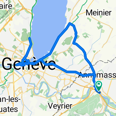
Overview
About this route
The Saleve on Wednesday ;-)
- -:--
- Duration
- 32 km
- Distance
- 864 m
- Ascent
- 857 m
- Descent
- ---
- Avg. speed
- ---
- Max. altitude

Route quality
Waytypes & surfaces along the route
Waytypes
Road
21.7 km
(68 %)
Quiet road
0.6 km
(2 %)
Undefined
9.6 km
(30 %)
Surfaces
Paved
24.3 km
(76 %)
Asphalt
24.3 km
(76 %)
Undefined
7.7 km
(24 %)
Continue with Bikemap
Use, edit, or download this cycling route
You would like to ride Le saleve or customize it for your own trip? Here is what you can do with this Bikemap route:
Free features
- Save this route as favorite or in collections
- Copy & plan your own version of this route
- Sync your route with Garmin or Wahoo
Premium features
Free trial for 3 days, or one-time payment. More about Bikemap Premium.
- Navigate this route on iOS & Android
- Export a GPX / KML file of this route
- Create your custom printout (try it for free)
- Download this route for offline navigation
Discover more Premium features.
Get Bikemap PremiumFrom our community
Other popular routes starting in Étrembières
 Route des Grandes Alpes 2019 Alt. 2.1 - Tag 1
- Distance
- 93.5 km
- Ascent
- 1,856 m
- Descent
- 1,550 m
- Location
- Étrembières, Auvergne-Rhône-Alpes, France
 MONT SALÈVE, por Annemasse
- Distance
- 13.3 km
- Ascent
- 917 m
- Descent
- 54 m
- Location
- Étrembières, Auvergne-Rhône-Alpes, France
 SALEVE depuis Etrambière
- Distance
- 11.7 km
- Ascent
- 840 m
- Descent
- 53 m
- Location
- Étrembières, Auvergne-Rhône-Alpes, France
 Botoela_3
- Distance
- 5 km
- Ascent
- 442 m
- Descent
- 4 m
- Location
- Étrembières, Auvergne-Rhône-Alpes, France
 Petit Salève (Montée difficile)
- Distance
- 10.1 km
- Ascent
- 512 m
- Descent
- 513 m
- Location
- Étrembières, Auvergne-Rhône-Alpes, France
 Route des Grandes Alpes - Tag 1
- Distance
- 108.7 km
- Ascent
- 2,758 m
- Descent
- 1,552 m
- Location
- Étrembières, Auvergne-Rhône-Alpes, France
 Gaillard-Bellegarde-St. Claude-Mouthe-Morteau-Gaumois-Les Chaux des Fonds-Grandson-Lausanne-Gaillard
- Distance
- 277.3 km
- Ascent
- 2,965 m
- Descent
- 2,382 m
- Location
- Étrembières, Auvergne-Rhône-Alpes, France
 Genfi nap
- Distance
- 31.9 km
- Ascent
- 175 m
- Descent
- 174 m
- Location
- Étrembières, Auvergne-Rhône-Alpes, France
Open it in the app