


day 15 to piraeus ferry to rhodes
- 110.4 km
- 325 m
- 320 m
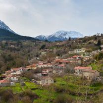
- Xylokastro, Peloponnese, Greece
Overview
This bike route starts from the Middle District of Trikala which is built at an altitude of 1050 meters on the slopes of Mount Kyllini and passes through Karya and Gkoura village. Karya or Karyes is a mountainous village in the prefecture of Korinthia, west of Kiato. It is built at an altitude of 1,300 meters on the slopes of Ziria and is one of the most mountainous settlements of the Peloponnese. Goura on the other hand is located at an altitude of 950 metres on the western slopes of Mount Zireia in the valley of the river Olvios, 91 kilometres south-west of Corinth
created this 7 years ago
Part of
3 stages
Route quality
Road
5.1 km
(7 %)
Track
2.2 km
(3 %)
Paved
39.5 km
(54 %)
Asphalt
39.5 km
(54 %)
Undefined
33.6 km
(46 %)
Continue with Bikemap
You would like to ride Trikala Medium or customize it for your own trip? Here is what you can do with this Bikemap route:
Free trial for 3 days, or one-time payment. More about Bikemap Premium.
Discover more Premium features.
Get Bikemap PremiumFrom our community
Open it in the app


