

Llano de la Perdiz, gracias Aguilera ^^.
A cycling route starting in Atarfe, Andalusia, Spain.
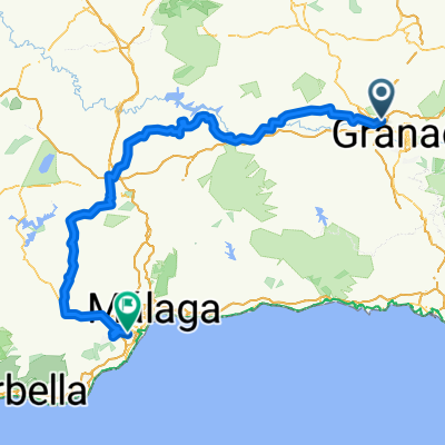
Overview
About this route
- -:--
- Duration
- 26.8 km
- Distance
- 569 m
- Ascent
- 295 m
- Descent
- ---
- Avg. speed
- ---
- Max. altitude

Route highlights
Points of interest along the route
Point of interest after 13.7 km
TAPIAS DEL CEMENTERIO: lugar de Memoria Histórica.
Drinking water after 16.1 km
Bajada a la Vereda Sur 1 que llega al Montículo-Salto y que se junta con la vereda viene del "Parque Acuático la Aquaola".
Drinking water after 16.7 km
Vereda Sur 2.
Bike service after 17.5 km
Vereda Norte 1 que atraviesa la carretera del Llano de la Perdíz, y que acaba en la "Mesa de Piedra" cerca del "Reloj de Sol".
Bike service after 17.8 km
Vereda Norte 2.
Bike service after 18 km
Vereda Norte 3.
Continue with Bikemap
Use, edit, or download this cycling route
You would like to ride Llano de la Perdiz, gracias Aguilera ^^. or customize it for your own trip? Here is what you can do with this Bikemap route:
Free features
- Save this route as favorite or in collections
- Copy & plan your own version of this route
- Sync your route with Garmin or Wahoo
Premium features
Free trial for 3 days, or one-time payment. More about Bikemap Premium.
- Navigate this route on iOS & Android
- Export a GPX / KML file of this route
- Create your custom printout (try it for free)
- Download this route for offline navigation
Discover more Premium features.
Get Bikemap PremiumFrom our community
Other popular routes starting in Atarfe
 Atarfe-Pantano Cubillas-Maracanilla-Moleona-Atarfe
- Distance
- 32.2 km
- Ascent
- 364 m
- Descent
- 364 m
- Location
- Atarfe, Andalusia, Spain
 granada malaga
- Distance
- 203.9 km
- Ascent
- 1,070 m
- Descent
- 1,617 m
- Location
- Atarfe, Andalusia, Spain
 Atarfe- Vega de Granada
- Distance
- 45.5 km
- Ascent
- 207 m
- Descent
- 207 m
- Location
- Atarfe, Andalusia, Spain
 Atarfe Illora Montefrio Olivares
- Distance
- 108 km
- Ascent
- 1,256 m
- Descent
- 1,254 m
- Location
- Atarfe, Andalusia, Spain
 Atarfe - Cogollos - Puerto Lobo - Atarfe
- Distance
- 68.1 km
- Ascent
- 1,102 m
- Descent
- 1,102 m
- Location
- Atarfe, Andalusia, Spain
 Atarfe Alomartes Atarfe
- Distance
- 67.8 km
- Ascent
- 494 m
- Descent
- 494 m
- Location
- Atarfe, Andalusia, Spain
 Se te pondrá malacara 100KM
- Distance
- 99.8 km
- Ascent
- 1,181 m
- Descent
- 1,181 m
- Location
- Atarfe, Andalusia, Spain
 Atarfe - Cogollos - Atarfe
- Distance
- 44.6 km
- Ascent
- 547 m
- Descent
- 547 m
- Location
- Atarfe, Andalusia, Spain
Open it in the app