

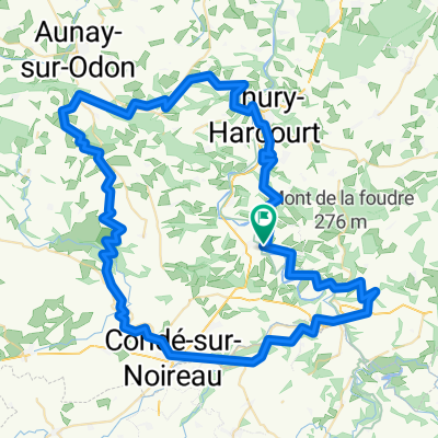
3éme étape Calva Camembert
A cycling route starting in Clécy, Normandy, France.
Overview
About this route
- -:--
- Duration
- 86.3 km
- Distance
- 774 m
- Ascent
- 774 m
- Descent
- ---
- Avg. speed
- ---
- Max. altitude

Route quality
Waytypes & surfaces along the route
Waytypes
Track
38.8 km
(45 %)
Quiet road
19 km
(22 %)
Surfaces
Paved
6 km
(7 %)
Unpaved
12.9 km
(15 %)
Ground
10.4 km
(12 %)
Asphalt
6 km
(7 %)
Route highlights
Points of interest along the route
Bike service after 19.7 km
1er ravitaillement Moulines 20.2km Dénivelé: 390m Latitude:48°59'17.85"N Longitude:0°20'23.01"O
Bike service after 41.1 km
2éme ravitaillement Epaney 41km Dénivelé 570m Latitude:48°56'51.95"N Longitude:0°10'5.17"O
Bike service after 64.1 km
3éme ravitaillement Le Mesnil Vin 64km Dénivelé 740m Latitude:48°50'39.12"N Longitude:0°19'7.18"O
Continue with Bikemap
Use, edit, or download this cycling route
You would like to ride 3éme étape Calva Camembert or customize it for your own trip? Here is what you can do with this Bikemap route:
Free features
- Save this route as favorite or in collections
- Copy & plan your own version of this route
- Split it into stages to create a multi-day tour
- Sync your route with Garmin or Wahoo
Premium features
Free trial for 3 days, or one-time payment. More about Bikemap Premium.
- Navigate this route on iOS & Android
- Export a GPX / KML file of this route
- Create your custom printout (try it for free)
- Download this route for offline navigation
Discover more Premium features.
Get Bikemap PremiumFrom our community
Other popular routes starting in Clécy
 1ére étape Calva Camembert
- Distance
- 86.6 km
- Ascent
- 1,173 m
- Descent
- 1,172 m
- Location
- Clécy, Normandy, France
 Parcours 100km Week-end Suisse Normande
- Distance
- 97.6 km
- Ascent
- 829 m
- Descent
- 810 m
- Location
- Clécy, Normandy, France
 Rouvrou -> Thury-Harcourt
- Distance
- 32.4 km
- Ascent
- 547 m
- Descent
- 580 m
- Location
- Clécy, Normandy, France
 Petite boucle en Suisse Normande
- Distance
- 22.4 km
- Ascent
- 460 m
- Descent
- 460 m
- Location
- Clécy, Normandy, France
 Place du Tripot, Clécy à Esplanade Jean-Marie Louvel, Caen
- Distance
- 39.8 km
- Ascent
- 56 m
- Descent
- 125 m
- Location
- Clécy, Normandy, France
 2016 Sept Day 3 99km 710m
- Distance
- 97.8 km
- Ascent
- 633 m
- Descent
- 645 m
- Location
- Clécy, Normandy, France
 Parcours 38km WE Suisse normande
- Distance
- 37.2 km
- Ascent
- 603 m
- Descent
- 600 m
- Location
- Clécy, Normandy, France
 Clécy - Gacé (Tour du Pays d'Auge, Etape 4)
- Distance
- 72.9 km
- Ascent
- 715 m
- Descent
- 484 m
- Location
- Clécy, Normandy, France
Open it in the app