
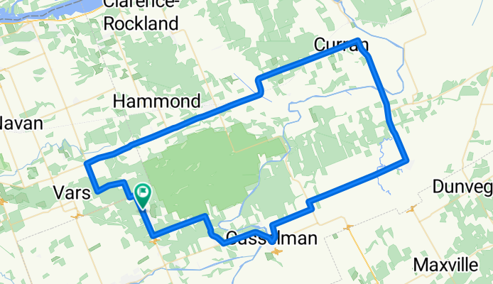
East loop to St. Isidore
A cycling route starting in Bourget, Ontario, Canada.
Overview
About this route
Mostly flat with a couple of hills. Hills are pretty good for how flat the area is. Roads are all in pretty good shape.
- -:--
- Duration
- 92.1 km
- Distance
- 73 m
- Ascent
- 75 m
- Descent
- ---
- Avg. speed
- ---
- Max. altitude

Route quality
Waytypes & surfaces along the route
Waytypes
Quiet road
22.1 km
(24 %)
Road
8.3 km
(9 %)
Undefined
61.7 km
(67 %)
Surfaces
Paved
63.5 km
(69 %)
Unpaved
1.8 km
(2 %)
Asphalt
34.1 km
(37 %)
Paved (undefined)
29.5 km
(32 %)
Continue with Bikemap
Use, edit, or download this cycling route
You would like to ride East loop to St. Isidore or customize it for your own trip? Here is what you can do with this Bikemap route:
Free features
- Save this route as favorite or in collections
- Copy & plan your own version of this route
- Split it into stages to create a multi-day tour
- Sync your route with Garmin or Wahoo
Premium features
Free trial for 3 days, or one-time payment. More about Bikemap Premium.
- Navigate this route on iOS & Android
- Export a GPX / KML file of this route
- Create your custom printout (try it for free)
- Download this route for offline navigation
Discover more Premium features.
Get Bikemap PremiumFrom our community
Other popular routes starting in Bourget
 South Osanbruck Loop
- Distance
- 104.5 km
- Ascent
- 99 m
- Descent
- 99 m
- Location
- Bourget, Ontario, Canada
 CD-QC Gatineau to Quebec City 2.0 - Bourget to Rigault
- Distance
- 83.7 km
- Ascent
- 150 m
- Descent
- 162 m
- Location
- Bourget, Ontario, Canada
 South loop through Ingleside
- Distance
- 121.7 km
- Ascent
- 75 m
- Descent
- 77 m
- Location
- Bourget, Ontario, Canada
 North east to Rockland and Wendover
- Distance
- 104.2 km
- Ascent
- 184 m
- Descent
- 186 m
- Location
- Bourget, Ontario, Canada
 East loop to St. Isidore
- Distance
- 92.1 km
- Ascent
- 73 m
- Descent
- 75 m
- Location
- Bourget, Ontario, Canada
 6- Camping Paradis au Camping St-Polycarpe
- Distance
- 93.2 km
- Ascent
- 385 m
- Descent
- 406 m
- Location
- Bourget, Ontario, Canada
 100km Loop
- Distance
- 103.5 km
- Ascent
- 129 m
- Descent
- 130 m
- Location
- Bourget, Ontario, Canada
 4348–4666 Indian Creek Rd, Clarence-Rockland to 4348–4666 Indian Creek Rd, Clarence-Rockland
- Distance
- 8.8 km
- Ascent
- 132 m
- Descent
- 136 m
- Location
- Bourget, Ontario, Canada
Open it in the app