

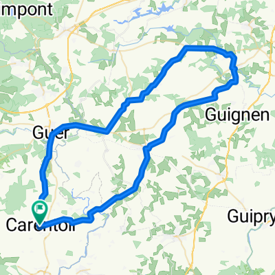
Carentoir VTT 36
A cycling route starting in Carentoir, Brittany Region, France.
Overview
About this route
36 kms easy, nice. Small well-sheltered path in the first part, after the farm of Boschat, super cool and pretty.
- -:--
- Duration
- 36 km
- Distance
- 315 m
- Ascent
- 314 m
- Descent
- ---
- Avg. speed
- ---
- Max. altitude
Continue with Bikemap
Use, edit, or download this cycling route
You would like to ride Carentoir VTT 36 or customize it for your own trip? Here is what you can do with this Bikemap route:
Free features
- Save this route as favorite or in collections
- Copy & plan your own version of this route
- Sync your route with Garmin or Wahoo
Premium features
Free trial for 3 days, or one-time payment. More about Bikemap Premium.
- Navigate this route on iOS & Android
- Export a GPX / KML file of this route
- Create your custom printout (try it for free)
- Download this route for offline navigation
Discover more Premium features.
Get Bikemap PremiumFrom our community
Other popular routes starting in Carentoir
 MT1-CL
- Distance
- 0.4 km
- Ascent
- 0 m
- Descent
- 0 m
- Location
- Carentoir, Brittany Region, France
 NE_Lassy_68
- Distance
- 67.8 km
- Ascent
- 536 m
- Descent
- 533 m
- Location
- Carentoir, Brittany Region, France
 N-Paimpont_73
- Distance
- 73.6 km
- Ascent
- 490 m
- Descent
- 488 m
- Location
- Carentoir, Brittany Region, France
 De 6 Rue de Clisson, Carentoir à 4 Place de Boston, Le Croisic
- Distance
- 97.3 km
- Ascent
- 665 m
- Descent
- 708 m
- Location
- Carentoir, Brittany Region, France
 St Servant SR 83 - ONO
- Distance
- 84.5 km
- Ascent
- 498 m
- Descent
- 500 m
- Location
- Carentoir, Brittany Region, France
 Beganne 87 SSO
- Distance
- 86.4 km
- Ascent
- 529 m
- Descent
- 532 m
- Location
- Carentoir, Brittany Region, France
 Carentoir VTT 36
- Distance
- 36 km
- Ascent
- 315 m
- Descent
- 314 m
- Location
- Carentoir, Brittany Region, France
 Piriac-Sud-91
- Distance
- 91.3 km
- Ascent
- 206 m
- Descent
- 239 m
- Location
- Carentoir, Brittany Region, France
Open it in the app