

MANGART/Predel z Pontebby i przez Tarvisio - ?
A cycling route starting in Pontebba, Friuli Venezia Giulia, Italy.
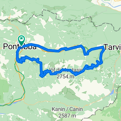
Overview
About this route
- -:--
- Duration
- 104.1 km
- Distance
- 2,015 m
- Ascent
- 2,013 m
- Descent
- ---
- Avg. speed
- ---
- Max. altitude
Route quality
Waytypes & surfaces along the route
Waytypes
Road
21.9 km
(21 %)
Cycleway
21.9 km
(21 %)
Surfaces
Paved
88.5 km
(85 %)
Asphalt
88.5 km
(85 %)
Undefined
15.6 km
(15 %)
Route highlights
Points of interest along the route
Accommodation after 0.1 km
Point of interest after 31 km
Photo after 39.3 km
Point of interest after 67.2 km
Point of interest after 91.6 km
Bike service after 91.9 km
??
Continue with Bikemap
Use, edit, or download this cycling route
You would like to ride MANGART/Predel z Pontebby i przez Tarvisio - ? or customize it for your own trip? Here is what you can do with this Bikemap route:
Free features
- Save this route as favorite or in collections
- Copy & plan your own version of this route
- Split it into stages to create a multi-day tour
- Sync your route with Garmin or Wahoo
Premium features
Free trial for 3 days, or one-time payment. More about Bikemap Premium.
- Navigate this route on iOS & Android
- Export a GPX / KML file of this route
- Create your custom printout (try it for free)
- Download this route for offline navigation
Discover more Premium features.
Get Bikemap PremiumFrom our community
Other popular routes starting in Pontebba
 TE Pontebba, Nassfeld, Tarvisio, Pontebba
- Distance
- 97.2 km
- Ascent
- 1,811 m
- Descent
- 1,804 m
- Location
- Pontebba, Friuli Venezia Giulia, Italy
 Pontebba-Pramollo-Monte Croce-Cason di Lanza
- Distance
- 120.9 km
- Ascent
- 3,191 m
- Descent
- 3,191 m
- Location
- Pontebba, Friuli Venezia Giulia, Italy
 Pontebba - Passo del Cason di Lanza - Pontebba
- Distance
- 96.4 km
- Ascent
- 1,918 m
- Descent
- 1,916 m
- Location
- Pontebba, Friuli Venezia Giulia, Italy
 malga poccet rifugio grego lussari
- Distance
- 76.4 km
- Ascent
- 2,563 m
- Descent
- 2,562 m
- Location
- Pontebba, Friuli Venezia Giulia, Italy
 2. nap Pontebba-Udine B. verzió (bicóutas)
- Distance
- 77.9 km
- Ascent
- 956 m
- Descent
- 1,405 m
- Location
- Pontebba, Friuli Venezia Giulia, Italy
 Alpe-Adria Pontebba - Villach
- Distance
- 60.9 km
- Ascent
- 720 m
- Descent
- 763 m
- Location
- Pontebba, Friuli Venezia Giulia, Italy
 rio degli uccelli, Pontebba
- Distance
- 3.9 km
- Ascent
- 200 m
- Descent
- 184 m
- Location
- Pontebba, Friuli Venezia Giulia, Italy
 Pontebba fino a Dongna con i bambini
- Distance
- 22.9 km
- Ascent
- 473 m
- Descent
- 466 m
- Location
- Pontebba, Friuli Venezia Giulia, Italy
Open it in the app