
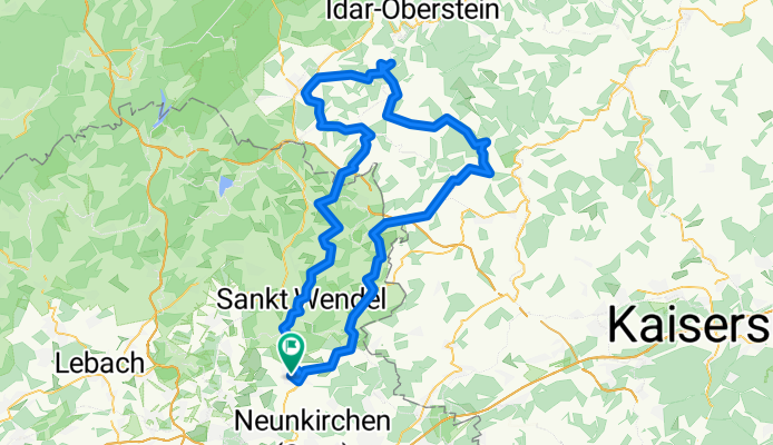
Blies-Nahe-Blies 2016 - RTF des RV 1893 Ottweiler e.V. - 112 km Strecke
A cycling route starting in Ottweiler, Saarland, Germany.
Overview
About this route
Blies-Nahe-Blies 2016 - 112 km
RTF des RV 1893 Ottweiler e.V.
Alle weiteren Hinweise zu dieser Strecke -> hier anklicken
- -:--
- Duration
- 111.7 km
- Distance
- 2,033 m
- Ascent
- 1,925 m
- Descent
- ---
- Avg. speed
- 545 m
- Max. altitude

Route quality
Waytypes & surfaces along the route
Waytypes
Busy road
60.2 km
(54 %)
Quiet road
18.4 km
(16 %)
Surfaces
Paved
87.6 km
(78 %)
Unpaved
6.7 km
(6 %)
Asphalt
75.7 km
(68 %)
Paved (undefined)
11.5 km
(10 %)
Route highlights
Points of interest along the route
Point of interest after 26.8 km
Kontrolle Pfeffelbach
Point of interest after 60.4 km
Kontrolle Kronweiler
Point of interest after 92.3 km
Kontrolle Reitscheid
Continue with Bikemap
Use, edit, or download this cycling route
You would like to ride Blies-Nahe-Blies 2016 - RTF des RV 1893 Ottweiler e.V. - 112 km Strecke or customize it for your own trip? Here is what you can do with this Bikemap route:
Free features
- Save this route as favorite or in collections
- Copy & plan your own version of this route
- Split it into stages to create a multi-day tour
- Sync your route with Garmin or Wahoo
Premium features
Free trial for 3 days, or one-time payment. More about Bikemap Premium.
- Navigate this route on iOS & Android
- Export a GPX / KML file of this route
- Create your custom printout (try it for free)
- Download this route for offline navigation
Discover more Premium features.
Get Bikemap PremiumFrom our community
Other popular routes starting in Ottweiler
 MTB 6 Ausdauer-Tour
- Distance
- 34.6 km
- Ascent
- 713 m
- Descent
- 712 m
- Location
- Ottweiler, Saarland, Germany
 Kleine OTW Ostertalrunde
- Distance
- 19.3 km
- Ascent
- 303 m
- Descent
- 305 m
- Location
- Ottweiler, Saarland, Germany
 CTF Niederlinxweiler 201106
- Distance
- 52.7 km
- Ascent
- 772 m
- Descent
- 772 m
- Location
- Ottweiler, Saarland, Germany
 Auf ein Weizen zum Wolfsborner Hof 3.8.18
- Distance
- 48.4 km
- Ascent
- 560 m
- Descent
- 511 m
- Location
- Ottweiler, Saarland, Germany
 RTF Ottweiler
- Distance
- 110.3 km
- Ascent
- 1,054 m
- Descent
- 1,054 m
- Location
- Ottweiler, Saarland, Germany
 Vom Spiemont zum Potzberg 2017 - RTF der St. Wendeler Bikebären e.V. - 50 km Strecke
- Distance
- 49.6 km
- Ascent
- 604 m
- Descent
- 605 m
- Location
- Ottweiler, Saarland, Germany
 Wiebelskirchen Weiher
- Distance
- 4.4 km
- Ascent
- 120 m
- Descent
- 112 m
- Location
- Ottweiler, Saarland, Germany
 RTF St. Wendel 107 km
- Distance
- 107 km
- Ascent
- 1,374 m
- Descent
- 1,374 m
- Location
- Ottweiler, Saarland, Germany
Open it in the app