

kleine Innsbrucker Nordkettenrunde
A cycling route starting in Völs, Tyrol, Austria.
Overview
About this route
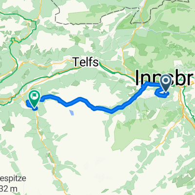
Small Nordkette loop above Innsbruck. Opposite the Franz Psenner bridge, ascend via the Heinrich Süß path up to the Alpenzoo. Pass right by the Alpenzoo and climb the Wilhelm-Greil path to Hungerburg. Warning: the Wilhelm-Greil path is actually closed to bikes, but uphill, thanks to sections with 22-25% gradient, you are hardly faster than hikers >>> no problems; downhill definitely not recommended!!! From Hungerburg, take the Rosner path towards Arzler Alm, but at the fork to Rumer Alm, turn towards Rumer Alm. At the next hairpin and fork to Rumer Alm, turn left uphill towards Höttigern Alm (Arzler Alm panoramic loop). At the next fork, where it goes right uphill to Höttinger Alm, continue straight and descend towards Arzler Alm. At the large hairpin, descend right towards Höttinger Bild and return to Innsbruck.
- -:--
- Duration
- 20.2 km
- Distance
- 697 m
- Ascent
- 695 m
- Descent
- ---
- Avg. speed
- ---
- Max. altitude

Continue with Bikemap
Use, edit, or download this cycling route
You would like to ride kleine Innsbrucker Nordkettenrunde or customize it for your own trip? Here is what you can do with this Bikemap route:
Free features
- Save this route as favorite or in collections
- Copy & plan your own version of this route
- Sync your route with Garmin or Wahoo
Premium features
Free trial for 3 days, or one-time payment. More about Bikemap Premium.
- Navigate this route on iOS & Android
- Export a GPX / KML file of this route
- Create your custom printout (try it for free)
- Download this route for offline navigation
Discover more Premium features.
Get Bikemap PremiumFrom our community
Other popular routes starting in Völs
 MTB IBK-Höttinger Alm
- Distance
- 21.9 km
- Ascent
- 944 m
- Descent
- 944 m
- Location
- Völs, Tyrol, Austria
 INNSBRUCK - STERZING (stadtplatz)
- Distance
- 58 km
- Ascent
- 994 m
- Descent
- 621 m
- Location
- Völs, Tyrol, Austria
 Kühtai Sattel 2009
- Distance
- 55.3 km
- Ascent
- 1,805 m
- Descent
- 1,740 m
- Location
- Völs, Tyrol, Austria
 Alpequer3
- Distance
- 237.3 km
- Ascent
- 4,005 m
- Descent
- 4,180 m
- Location
- Völs, Tyrol, Austria
 Inn túra 6.nap
- Distance
- 89.3 km
- Ascent
- 29 m
- Descent
- 119 m
- Location
- Völs, Tyrol, Austria
 Innsbruck - Scuol
- Distance
- 138.5 km
- Ascent
- 1,050 m
- Descent
- 372 m
- Location
- Völs, Tyrol, Austria
 Campingplatz Kranebitten - Höttinger Alm
- Distance
- 12.8 km
- Ascent
- 996 m
- Descent
- 122 m
- Location
- Völs, Tyrol, Austria
 Wipptalrunde
- Distance
- 48.4 km
- Ascent
- 705 m
- Descent
- 707 m
- Location
- Völs, Tyrol, Austria
Open it in the app