

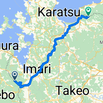
伊万里市黒川町
A cycling route starting in Imarichō-kō, Saga Prefecture, Japan.
Overview
About this route
- 29 min
- Duration
- 7.1 km
- Distance
- 155 m
- Ascent
- 152 m
- Descent
- 14.6 km/h
- Avg. speed
- ---
- Max. altitude

Route quality
Waytypes & surfaces along the route
Waytypes
Cycleway
1.5 km
(21 %)
Track
1 km
(14 %)
Surfaces
Unpaved
1 km
(14 %)
Gravel
0.7 km
(10 %)
Unpaved (undefined)
0.3 km
(4 %)
Undefined
6.1 km
(86 %)
Continue with Bikemap
Use, edit, or download this cycling route
You would like to ride 伊万里市黒川町 or customize it for your own trip? Here is what you can do with this Bikemap route:
Free features
- Save this route as favorite or in collections
- Copy & plan your own version of this route
- Sync your route with Garmin or Wahoo
Premium features
Free trial for 3 days, or one-time payment. More about Bikemap Premium.
- Navigate this route on iOS & Android
- Export a GPX / KML file of this route
- Create your custom printout (try it for free)
- Download this route for offline navigation
Discover more Premium features.
Get Bikemap PremiumFrom our community
Other popular routes starting in Imarichō-kō
 伊万里市黒川町
- Distance
- 7.1 km
- Ascent
- 155 m
- Descent
- 152 m
- Location
- Imarichō-kō, Saga Prefecture, Japan
 Kō, Imari nach Oki
- Distance
- 102.5 km
- Ascent
- 784 m
- Descent
- 786 m
- Location
- Imarichō-kō, Saga Prefecture, Japan
 2005/05/03伊万里-武雄
- Distance
- 30.3 km
- Ascent
- 278 m
- Descent
- 260 m
- Location
- Imarichō-kō, Saga Prefecture, Japan
 Imarichō-kō - Karatsu
- Distance
- 58.2 km
- Ascent
- 1,722 m
- Descent
- 2,004 m
- Location
- Imarichō-kō, Saga Prefecture, Japan
 imari via schir karatsu
- Distance
- 68.3 km
- Ascent
- 418 m
- Descent
- 423 m
- Location
- Imarichō-kō, Saga Prefecture, Japan
 山代町楠久471, 伊万里市 to 調川町下免695-1, 松浦市
- Distance
- 16.8 km
- Ascent
- 483 m
- Descent
- 487 m
- Location
- Imarichō-kō, Saga Prefecture, Japan
Open it in the app