

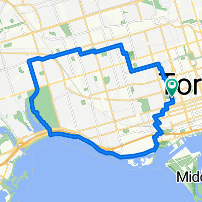
Earl Bales without Phil Nic
A cycling route starting in Toronto, Ontario, Canada.
Overview
About this route
Hot, humid, started raining at the end, it was good. Went partway down the hill and then turned left early, dragged my bike up a steep dirt hill then found myself at the campfire area, circled around and kept going around the park for a while. It's impossible to represent on this stupid map, think it was closer to 15 km or o but its really hard to tell. mood 8/10 brutality 4/10
- -:--
- Duration
- 12.3 km
- Distance
- 52 m
- Ascent
- 49 m
- Descent
- ---
- Avg. speed
- ---
- Max. altitude
Continue with Bikemap
Use, edit, or download this cycling route
You would like to ride Earl Bales without Phil Nic or customize it for your own trip? Here is what you can do with this Bikemap route:
Free features
- Save this route as favorite or in collections
- Copy & plan your own version of this route
- Sync your route with Garmin or Wahoo
Premium features
Free trial for 3 days, or one-time payment. More about Bikemap Premium.
- Navigate this route on iOS & Android
- Export a GPX / KML file of this route
- Create your custom printout (try it for free)
- Download this route for offline navigation
Discover more Premium features.
Get Bikemap PremiumFrom our community
Other popular routes starting in Toronto
 - Short steep climbs & fast descents in the Beach
- Distance
- 5.4 km
- Ascent
- 107 m
- Descent
- 110 m
- Location
- Toronto, Ontario, Canada
 East York to Indian Line campground
- Distance
- 47.4 km
- Ascent
- 242 m
- Descent
- 143 m
- Location
- Toronto, Ontario, Canada
 Gerrard Street East 257, Toronto to Waterfront Trail
- Distance
- 33.8 km
- Ascent
- 250 m
- Descent
- 265 m
- Location
- Toronto, Ontario, Canada
 Cedarvale Park
- Distance
- 5.9 km
- Ascent
- 39 m
- Descent
- 39 m
- Location
- Toronto, Ontario, Canada
 -Short Steep climbs & fast descents in the Beach
- Distance
- 5.2 km
- Ascent
- 98 m
- Descent
- 108 m
- Location
- Toronto, Ontario, Canada
 High Park
- Distance
- 18.4 km
- Ascent
- 63 m
- Descent
- 63 m
- Location
- Toronto, Ontario, Canada
 Thicc bike bois
- Distance
- 61.3 km
- Ascent
- 173 m
- Descent
- 170 m
- Location
- Toronto, Ontario, Canada
 Cabana
- Distance
- 13.1 km
- Ascent
- 91 m
- Descent
- 93 m
- Location
- Toronto, Ontario, Canada
Open it in the app